Poster Print > Fine Art Storehouse > Map
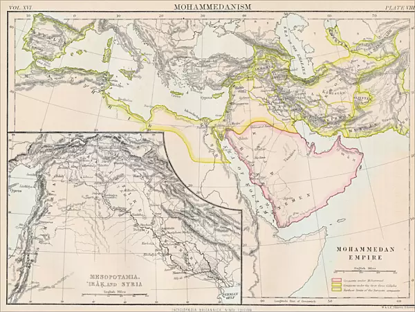
Poster Print : Mohammedan empire map 1883


![]()
Poster Prints from Fine Art Storehouse
Mohammedan empire map 1883
Encyclopedia Britannica 9th Edition New York Samuel L. Hall 1883 Vol XVI
Unleash your creativity and transform your space into a visual masterpiece!
THEPALMER
Media ID 14756730
© This content is subject to copyright
Empire Mesopotamia Syria Mohammedan Muhammad
18x24 inch Poster Print
Step back in time with our exquisite Mohammedan Empire Map Print from Media Storehouse, featuring the intricate and detailed work of THEPALMER from the Encyclopedia Britannica 9th Edition (New York, 1883). This historical poster print, taken from Volume XVI, showcases an accurate representation of the Mohammedan Empire as it existed in 1883. A fascinating addition to any home or office, this poster print is a captivating reminder of the rich history and complexity of the Islamic world. Bring a piece of history into your space and add depth to your decor with this unique and educational poster print.
Poster prints are budget friendly enlarged prints in standard poster paper sizes. Printed on 150 gsm Matte Paper for a natural feel and supplied rolled in a tube. Great for framing and should last many years. To clean wipe with a microfiber, non-abrasive cloth or napkin. Our Archival Quality Photo Prints and Fine Art Paper Prints are printed on higher quality paper and the choice of which largely depends on your budget.
Poster prints are budget friendly enlarged prints in standard poster paper sizes (A0, A1, A2, A3 etc). Whilst poster paper is sometimes thinner and less durable than our other paper types, they are still ok for framing and should last many years. Our Archival Quality Photo Prints and Fine Art Paper Prints are printed on higher quality paper and the choice of which largely depends on your budget.
Estimated Product Size is 61.6cm x 46.3cm (24.3" x 18.2")
These are individually made so all sizes are approximate
Artwork printed orientated as per the preview above, with landscape (horizontal) orientation to match the source image.
FEATURES IN THESE COLLECTIONS
> Fine Art Storehouse
> Map
> Historical Maps
EDITORS COMMENTS
In this print titled "Mohammedan Empire Map 1883" we are transported back in time to an era of great historical significance. The image showcases a meticulously detailed map from the renowned Encyclopedia Britannica's 9th Edition, published in New York by Samuel L. Hall in 1883. The map itself is a testament to the vastness and grandeur of the Mohammedan Empire during its peak. It encompasses regions that were once under Islamic rule, including Mesopotamia, Syria, and other territories that played pivotal roles in shaping world history. As we gaze upon this remarkable piece of artistry by THEPALMER, our imagination takes flight as we envision caravans traversing ancient trade routes, bustling marketplaces filled with vibrant colors and exotic goods, and scholars engaging in intellectual pursuits within magnificent Islamic centers of learning. This photograph not only serves as a visual delight but also invites us to delve deeper into the rich cultural heritage and contributions made by the Mohammedan Empire. It reminds us of the significant role Islam has played throughout history - fostering advancements in science, mathematics, architecture, literature, and more. "The Mohammedan Empire Map 1883" is a true treasure for enthusiasts of both cartography and history alike. Its intricate details transport us back to an era when empires rose and fell while leaving indelible imprints on civilization's tapestry.
MADE IN THE USA
Safe Shipping with 30 Day Money Back Guarantee
FREE PERSONALISATION*
We are proud to offer a range of customisation features including Personalised Captions, Color Filters and Picture Zoom Tools
SECURE PAYMENTS
We happily accept a wide range of payment options so you can pay for the things you need in the way that is most convenient for you
* Options may vary by product and licensing agreement. Zoomed Pictures can be adjusted in the Cart.