Poster Print > Oceania > New Zealand > Maps
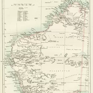
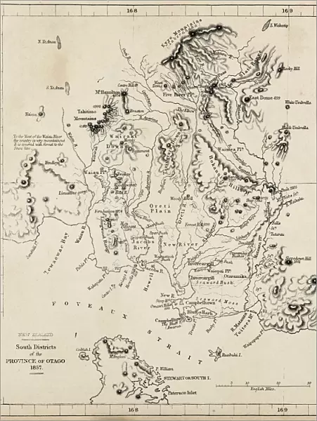
Poster Print : Map of the Otago Region in New Zealand - 19th Century


![]()
Poster Prints from Fine Art Storehouse
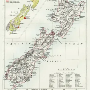
Map of the Otago Region in New Zealand - 19th Century
19th century map of the Otago region in the South Island, New Zealand
Unleash your creativity and transform your space into a visual masterpiece!
powerofforever
Media ID 19314439
18x24 inch Poster Print
Step back in time with our exquisite Map of the Otago Region in New Zealand from the 19th Century. This stunning reproduction, sourced from the Fine Art Storehouse, showcases intricate details of the South Island's Otago region during a bygone era. Add an air of historical charm to your space with this beautifully preserved piece of cartographic history. Ideal for avid collectors, history enthusiasts, or anyone who appreciates the beauty of vintage maps. Order yours today and let this captivating print transport you back in time.
Poster prints are budget friendly enlarged prints in standard poster paper sizes. Printed on 150 gsm Matte Paper for a natural feel and supplied rolled in a tube. Great for framing and should last many years. To clean wipe with a microfiber, non-abrasive cloth or napkin. Our Archival Quality Photo Prints and Fine Art Paper Prints are printed on higher quality paper and the choice of which largely depends on your budget.
Poster prints are budget friendly enlarged prints in standard poster paper sizes (A0, A1, A2, A3 etc). Whilst poster paper is sometimes thinner and less durable than our other paper types, they are still ok for framing and should last many years. Our Archival Quality Photo Prints and Fine Art Paper Prints are printed on higher quality paper and the choice of which largely depends on your budget.
Estimated Product Size is 46.3cm x 61.6cm (18.2" x 24.3")
These are individually made so all sizes are approximate
Artwork printed orientated as per the preview above, with portrait (vertical) orientation to match the source image.
FEATURES IN THESE COLLECTIONS
> Fine Art Storehouse
> Map
> Historical Maps
> Maps and Charts
> Related Images
> Oceania
> New Zealand
> Maps
> Oceania
> New Zealand
> Related Images
EDITORS COMMENTS
This 19th-century map of the Otago Region in New Zealand, captured by powerofforever and available at Fine Art Storehouse, is a true testament to the rich history and natural beauty of this South Island gem. With intricate details and vibrant colors, this print takes us on a journey back in time to explore the region's past. The map showcases not only the geographical features but also provides insights into early settlements, indigenous Maori landmarks, and important trade routes that shaped Otago's development. It serves as a window into an era when exploration was at its peak and discoveries were being made. As we gaze upon this stunning piece of art, our imaginations are ignited with thoughts of intrepid explorers navigating through Foveaux Strait or settlers venturing inland to establish new communities. The attention to detail allows us to envision what life might have been like during those times - bustling ports filled with ships from distant lands or vast stretches of untouched wilderness waiting to be discovered. Whether you have a personal connection to Otago or simply appreciate historical maps as works of art, this print is sure to captivate your senses. Hang it proudly on your wall as a conversation starter or gift it to someone who shares your passion for history and adventure. Let yourself be transported back in time every time you glance at this remarkable depiction of the Otago Region in all its 19th-century glory.
MADE IN THE USA
Safe Shipping with 30 Day Money Back Guarantee
FREE PERSONALISATION*
We are proud to offer a range of customisation features including Personalised Captions, Color Filters and Picture Zoom Tools
SECURE PAYMENTS
We happily accept a wide range of payment options so you can pay for the things you need in the way that is most convenient for you
* Options may vary by product and licensing agreement. Zoomed Pictures can be adjusted in the Cart.