Poster Print > Europe > Italy > Lazio > Rome
Poster Print : Geography map: representation of Turtle Island off Hispaniola near the Passage of the Winds between Cuba and Hispaniola, made by Dutch cartographer Gerard van Keulen (1678-1726) 1709-1713. Biblioteca Angelica, Rome
 1709-1713. Biblioteca Angelica, Rome")

![]()
Poster Prints From Fine Art Finder
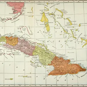
Geography map: representation of Turtle Island off Hispaniola near the Passage of the Winds between Cuba and Hispaniola, made by Dutch cartographer Gerard van Keulen (1678-1726) 1709-1713. Biblioteca Angelica, Rome
VEN5030175 Geography map: representation of Turtle Island off Hispaniola near the Passage of the Winds between Cuba and Hispaniola, made by Dutch cartographer Gerard van Keulen (1678-1726) 1709-1713. Biblioteca Angelica, Rome; (add.info.: Geography map: representation of Turtle Island off Hispaniola near the Passage of the Winds between Cuba and Hispaniola, made by Dutch cartographer Gerard van Keulen (1678-1726) 1709-1713. Biblioteca Angelica, Rome); © Marage Photos
Media ID 38484886
© © Marage Photos / Bridgeman Images
Amerique Centrale Amerique Du Nord Carte Geographique Central America Etats Unis Geographie Stockravenna 18eme Siecle Geographical Map
18x24 inch Poster Print
Explore the world's rich history with our Media Storehouse range of Poster Prints. This stunning map print features a rare representation of Turtle Island off Hispaniola, created by Dutch cartographer Gerard van Keulen in the early 18th century. With its intricate details and vintage charm, this poster is perfect for anyone who loves geography, history, or simply beautiful art. Bring a piece of the past into your home with our high-quality prints.
Poster prints are budget friendly enlarged prints in standard poster paper sizes. Printed on 150 gsm Matte Paper for a natural feel and supplied rolled in a tube. Great for framing and should last many years. To clean wipe with a microfiber, non-abrasive cloth or napkin. Our Archival Quality Photo Prints and Fine Art Paper Prints are printed on higher quality paper and the choice of which largely depends on your budget.
Poster prints are budget friendly enlarged prints in standard poster paper sizes (A0, A1, A2, A3 etc). Whilst poster paper is sometimes thinner and less durable than our other paper types, they are still ok for framing and should last many years. Our Archival Quality Photo Prints and Fine Art Paper Prints are printed on higher quality paper and the choice of which largely depends on your budget.
Estimated Product Size is 61.6cm x 46.3cm (24.3" x 18.2")
These are individually made so all sizes are approximate
Artwork printed orientated as per the preview above, with landscape (horizontal) orientation to match the source image.
FEATURES IN THESE COLLECTIONS
> Europe
> Italy
> Lazio
> Rome
> Maps and Charts
> Early Maps
> Maps and Charts
> Related Images
> North America
> Cuba
> Maps
> North America
> Cuba
> Related Images
> North America
> United States of America
> Maps
> Popular Themes
> North Island
EDITORS COMMENTS
This stunning geography map, created by Dutch cartographer Gerard van Keulen in the early 18th century, offers a fascinating glimpse into the intricate details of Turtle Island off Hispaniola near the Passage of the Winds between Cuba and Hispaniola. The map, housed at Biblioteca Angelica in Rome, showcases van Keulen's meticulous attention to detail and skillful craftsmanship.
The representation of Turtle Island on this map is not only visually captivating but also serves as a valuable historical document, providing insights into the geographical knowledge and exploration of that era. The intricate engravings and precise markings on the map highlight van Keulen's expertise in cartography and his dedication to accurately depicting the world around him.
As we gaze upon this piece of artistry from centuries past, we are transported back in time to an age of discovery and exploration. The map serves as a reminder of humanity's insatiable curiosity about our planet and its diverse landscapes. It stands as a testament to the enduring legacy of those who sought to chart unknown territories and expand our understanding of the world we inhabit.
Through this geography map, we gain not only a visual representation of Turtle Island but also a deeper appreciation for the rich history behind it. Van Keulen's masterpiece continues to inspire awe and wonder today, reminding us of our shared connection to both land and sea.
MADE IN THE USA
Safe Shipping with 30 Day Money Back Guarantee
FREE PERSONALISATION*
We are proud to offer a range of customisation features including Personalised Captions, Color Filters and Picture Zoom Tools
SECURE PAYMENTS
We happily accept a wide range of payment options so you can pay for the things you need in the way that is most convenient for you
* Options may vary by product and licensing agreement. Zoomed Pictures can be adjusted in the Basket.