Poster Print > Europe > United Kingdom > England > London > Politics > Arthur Wellesley
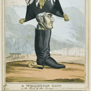
Poster Print : Map of Spain said to have been used by the Duke of Wellington


![]()
Poster Prints From Fine Art Finder
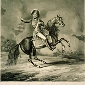
Map of Spain said to have been used by the Duke of Wellington
1772186 Map of Spain said to have been used by the Duke of Wellington, 1808-14 (coloured engraving) by English School, (19th century); National Army Museum, London; (add.info.: Arthur Wellesley (1 May 1769 - 14 September 1852) rose to prominence as a general during the Peninsular campaign. He was made Duke of Wellington in 1814 and finally defeated Napoleon at Waterloo the following year.); eNational Army Museum; English, out of copyright
Media ID 22862464
© National Army Museum / Bridgeman Images
Arthur Wellesley Duke Of Wellington Iberia Iberian Peninsula Mediterranean Sea Napoleonic Wars Peninsula Campaign Peninsula War Pyrenees Strategy
18x24 inch Poster Print
Step back in time with our exquisite Map of Spain poster print from the Media Storehouse collection. This captivating engraving, sourced from Bridgeman Images and Fine Art Finder, is said to have been used by the Duke of Wellington during his campaigns in Spain from 1808-1814. Add a touch of historical charm to your space with this beautifully colored and intricately detailed representation of Spain during the Napoleonic Wars. Bringing the past to life, this poster print makes a perfect addition to any home office, study, or history enthusiast's collection.
Poster prints are budget friendly enlarged prints in standard poster paper sizes. Printed on 150 gsm Matte Paper for a natural feel and supplied rolled in a tube. Great for framing and should last many years. To clean wipe with a microfiber, non-abrasive cloth or napkin. Our Archival Quality Photo Prints and Fine Art Paper Prints are printed on higher quality paper and the choice of which largely depends on your budget.
Poster prints are budget friendly enlarged prints in standard poster paper sizes (A0, A1, A2, A3 etc). Whilst poster paper is sometimes thinner and less durable than our other paper types, they are still ok for framing and should last many years. Our Archival Quality Photo Prints and Fine Art Paper Prints are printed on higher quality paper and the choice of which largely depends on your budget.
Estimated Product Size is 61.6cm x 46.3cm (24.3" x 18.2")
These are individually made so all sizes are approximate
Artwork printed orientated as per the preview above, with landscape (horizontal) orientation to match the source image.
FEATURES IN THESE COLLECTIONS
> Arts
> Artists
> S
> Spanish School
> Europe
> France
> Canton
> Pyrenees
> Europe
> United Kingdom
> England
> London
> Museums
> National Army Museum
> Europe
> United Kingdom
> England
> London
> Politics
> Arthur Wellesley
> Europe
> United Kingdom
> England
> London
> Towns
> Waterloo
EDITORS COMMENTS
This print showcases a historic "Map of Spain said to have been used by the Duke of Wellington" during the tumultuous years of 1808-1814. Created by an anonymous English School artist in the 19th century, this coloured engraving is now housed at the National Army Museum in London. The map holds immense significance as it sheds light on Arthur Wellesley's remarkable military career and his strategic prowess during the Peninsular campaign. Rising through the ranks, Wellesley became known as the Duke of Wellington in 1814 after achieving numerous victories against Napoleon's forces. Ultimately, he solidified his legacy by defeating Napoleon at Waterloo in 1815. As we delve into this intricate artwork, we are transported back to a time when Spain was embroiled in conflict between Spanish and French troops. The map vividly depicts key regions such as the Pyrenees and Iberian Peninsula while highlighting significant cities and waterways like Madrid and the Mediterranean Sea. With its meticulous detail and historical context, this engraving offers us a glimpse into Europe's turbulent Napoleonic Wars era. It serves not only as a testament to Wellington's military genius but also as a valuable artifact that encapsulates an important chapter in European history. Bridgeman Images has expertly captured this extraordinary piece from Fine Art Finder, allowing us to appreciate its beauty and historical significance for generations to come.
MADE IN THE USA
Safe Shipping with 30 Day Money Back Guarantee
FREE PERSONALISATION*
We are proud to offer a range of customisation features including Personalised Captions, Color Filters and Picture Zoom Tools
SECURE PAYMENTS
We happily accept a wide range of payment options so you can pay for the things you need in the way that is most convenient for you
* Options may vary by product and licensing agreement. Zoomed Pictures can be adjusted in the Basket.