Poster Print > Animals > Mammals > Muridae > Water Mouse
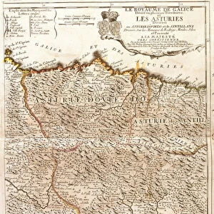
Poster Print : Map of Africa (etching, 1730)
")

![]()
Poster Prints From Fine Art Finder
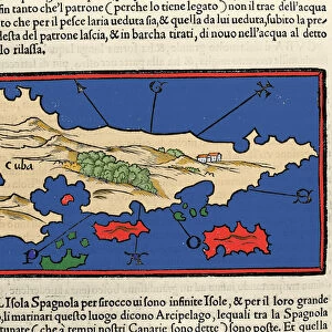
Map of Africa (etching, 1730)
LRI4706860 Map of Africa (etching, 1730) by Delisle, Guillaume (1675-1726); Private Collection; (add.info.: Map of Africa - Strong water extracted from the " New Atlas containing all parts of the world" 1730 by Guillaume de L Isle (1675-1726)); Luisa Ricciarini; French, out of copyright
Media ID 23734566
© Luisa Ricciarini / Bridgeman Images
18x24 inch Poster Print
Discover the rich history of cartography with our exquisite Map of Africa print from the Media Storehouse collection. This stunning etching, created by Guillaume Delisle in 1730, showcases an intriguing representation of the African continent as it was known during that time. With strong attention to detail and beautiful water extraction, this vintage map print brings a touch of history and elegance to any space. Copyrighted by Luisa Ricciarini from Fine Art Finder (LRI4706860).
Poster prints are budget friendly enlarged prints in standard poster paper sizes. Printed on 150 gsm Matte Paper for a natural feel and supplied rolled in a tube. Great for framing and should last many years. To clean wipe with a microfiber, non-abrasive cloth or napkin. Our Archival Quality Photo Prints and Fine Art Paper Prints are printed on higher quality paper and the choice of which largely depends on your budget.
Poster prints are budget friendly enlarged prints in standard poster paper sizes (A0, A1, A2, A3 etc). Whilst poster paper is sometimes thinner and less durable than our other paper types, they are still ok for framing and should last many years. Our Archival Quality Photo Prints and Fine Art Paper Prints are printed on higher quality paper and the choice of which largely depends on your budget.
Estimated Product Size is 61.6cm x 46.3cm (24.3" x 18.2")
These are individually made so all sizes are approximate
Artwork printed orientated as per the preview above, with landscape (horizontal) orientation to match the source image.
FEATURES IN THESE COLLECTIONS
> Fine Art Finder
> Artists
> Franz Hogenberg
> Fine Art Finder
> Artists
> Guillaume Delisle
> Africa
> South Africa
> Maps
> Africa
> South Africa
> Related Images
> Animals
> Mammals
> Muridae
> Water Mouse
> Maps and Charts
> Related Images
> Maps and Charts
> World
EDITORS COMMENTS
This print showcases a remarkable piece of cartographic history - the "Map of Africa" etching from 1730. Created by the renowned French cartographer Guillaume de L'Isle, this intricate map offers a fascinating glimpse into the geographical knowledge and artistic skill of the time. The etching depicts Africa in stunning detail, with its diverse landscapes and vast territories. From North Africa to South Africa, every region is meticulously outlined, providing an invaluable resource for explorers and scholars alike. The delicate lines and precise markings showcase De L'Isle's mastery in capturing both accuracy and beauty on paper. Originally featured in De L'Isle's comprehensive atlas titled "New Atlas containing all parts of the world" this particular map has stood the test of time as a testament to human curiosity about our planet. It serves as a reminder that even centuries ago, people were driven to explore and understand their surroundings. Thanks to Luisa Ricciarini's expert photography skills, we can now admire this historical masterpiece up close. The richness of colors and fine details captured in this print truly bring out the essence of De L'Isle's original work. Whether you are an art enthusiast or a lover of history, this print is sure to transport you back in time while igniting your sense of wonder about our ever-evolving world.
MADE IN THE USA
Safe Shipping with 30 Day Money Back Guarantee
FREE PERSONALISATION*
We are proud to offer a range of customisation features including Personalised Captions, Color Filters and Picture Zoom Tools
SECURE PAYMENTS
We happily accept a wide range of payment options so you can pay for the things you need in the way that is most convenient for you
* Options may vary by product and licensing agreement. Zoomed Pictures can be adjusted in the Basket.