Poster Print > Europe > Italy > Related Images
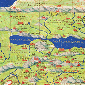
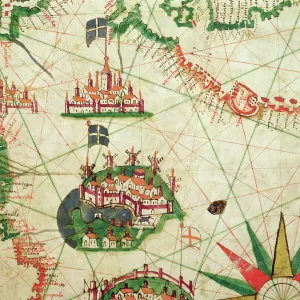
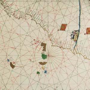
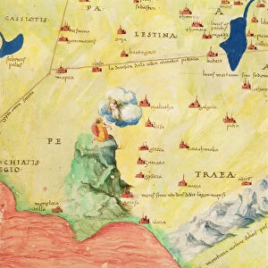
Poster Print : The Continent of Europe, from an Atlas of the World in 33 Maps, Venice, 1st September 1553


![]()
Poster Prints From Fine Art Finder
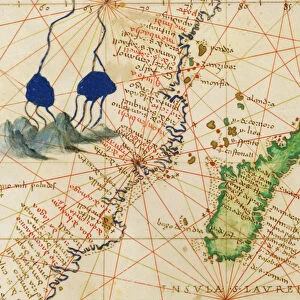
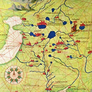
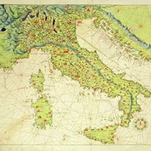
The Continent of Europe, from an Atlas of the World in 33 Maps, Venice, 1st September 1553
XOT330949 The Continent of Europe, from an Atlas of the World in 33 Maps, Venice, 1st September 1553 (ink on vellum) (see also 330950) by Agnese, Battista (1514-64); 29x49 cm; Museo Correr, Venice, Italy; Italian, out of copyright
Media ID 12852664
© www.bridgemanart.com
Mapping Monarchs Nautical Chart Navigation Portolan Rulers
18x24 inch Poster Print
Step back in time with our exquisite selection of vintage Map Prints from the Media Storehouse range. This particular print showcases a captivating and intricately detailed representation of Europe as depicted in "The Continent of Europe, from an Atlas of the World in 33 Maps," created in Venice on the 1st of September, 1553. Produced by the master cartographer Battista Agnese, this rare piece offers a unique glimpse into the historical geography of Europe during the Renaissance era. Each print is meticulously reproduced from the original ink on vellum at Bridgeman Art Library, ensuring the highest quality and authenticity. Add an air of antiquity and sophistication to your living space with this beautiful and enlightening addition to your decor.
Poster prints are budget friendly enlarged prints in standard poster paper sizes. Printed on 150 gsm Matte Paper for a natural feel and supplied rolled in a tube. Great for framing and should last many years. To clean wipe with a microfiber, non-abrasive cloth or napkin. Our Archival Quality Photo Prints and Fine Art Paper Prints are printed on higher quality paper and the choice of which largely depends on your budget.
Poster prints are budget friendly enlarged prints in standard poster paper sizes (A0, A1, A2, A3 etc). Whilst poster paper is sometimes thinner and less durable than our other paper types, they are still ok for framing and should last many years. Our Archival Quality Photo Prints and Fine Art Paper Prints are printed on higher quality paper and the choice of which largely depends on your budget.
Estimated Product Size is 61.6cm x 46.3cm (24.3" x 18.2")
These are individually made so all sizes are approximate
Artwork printed orientated as per the preview above, with landscape (horizontal) orientation to match the source image.
FEATURES IN THESE COLLECTIONS
> Fine Art Finder
> Artists
> Battista Agnese
> Fine Art Finder
> Maps (celestial & Terrestrial)
> Europe
> Italy
> Related Images
EDITORS COMMENTS
This print showcases "The Continent of Europe" from an ancient atlas, meticulously crafted by the talented cartographer Battista Agnese in Venice on 1st September 1553. The artwork, rendered with ink on vellum, measures a remarkable 29x49 cm and is currently housed at the Museo Correr in Venice, Italy. Agnese's masterpiece depicts Europe as it was known during the Renaissance period. This exquisite portolan chart offers a unique insight into the geographical understanding and navigational techniques of that era. With intricate details and precision, Agnese presents us with a visual representation of European territories, coastlines, rivers, mountains, and cities. As we gaze upon this historic map print today, we are transported back to a time when rulers and monarchs relied heavily on such charts for their conquests and explorations. It serves as a testament to human curiosity about the world beyond our immediate surroundings. Notably significant is how this artwork captures both scientific accuracy and artistic beauty simultaneously. Agnese's mastery lies not only in his ability to create an informative map but also in his talent for transforming it into an aesthetic marvel. "The Continent of Europe" evokes awe-inspiring wonder as we contemplate its historical significance while appreciating its timeless allure. Through this image captured by Fine Art Finder from www. bridgemanart. com , we can delve into the rich tapestry of European history through one man's vision brought to life centuries ago.
MADE IN THE USA
Safe Shipping with 30 Day Money Back Guarantee
FREE PERSONALISATION*
We are proud to offer a range of customisation features including Personalised Captions, Color Filters and Picture Zoom Tools
SECURE PAYMENTS
We happily accept a wide range of payment options so you can pay for the things you need in the way that is most convenient for you
* Options may vary by product and licensing agreement. Zoomed Pictures can be adjusted in the Basket.