Poster Print > Europe > United Kingdom > England > London > Museums > National Maritime Museum
Poster Print : Polar projection map with Arctic Circle, c.1680 (coloured engraving)
")

![]()
Poster Prints From Fine Art Finder
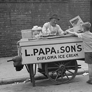
Polar projection map with Arctic Circle, c.1680 (coloured engraving)
7295393 Polar projection map with Arctic Circle, c.1680 (coloured engraving) by Seller, John (1632-97); 44x55 cm; National Maritime Museum, London, UK; (add.info.: Creator: John Seller
A mapp of the regions & countreyes under and about the North Pole by John Seller, hydrographer to the King.'); © National Maritime Museum, Greenwich, London
Media ID 38516416
© © National Maritime Museum, Greenwich, London / Bridgeman Images
Arctic Arctic Circle North Pole 17th Centuries
18x24 inch Poster Print
Step into the past with our Media Storehouse range of Poster Prints! This stunning 'Polar projection map with Arctic Circle' print takes you on a journey through time and space. Originally created in 1680 by Seller John, this coloured engraving is now available as a high-quality poster for your home or office. Perfect for anyone fascinated by history, geography, or the wonders of the natural world.
Poster prints are budget friendly enlarged prints in standard poster paper sizes. Printed on 150 gsm Matte Paper for a natural feel and supplied rolled in a tube. Great for framing and should last many years. To clean wipe with a microfiber, non-abrasive cloth or napkin. Our Archival Quality Photo Prints and Fine Art Paper Prints are printed on higher quality paper and the choice of which largely depends on your budget.
Poster prints are budget friendly enlarged prints in standard poster paper sizes (A0, A1, A2, A3 etc). Whilst poster paper is sometimes thinner and less durable than our other paper types, they are still ok for framing and should last many years. Our Archival Quality Photo Prints and Fine Art Paper Prints are printed on higher quality paper and the choice of which largely depends on your budget.
Estimated Product Size is 61.6cm x 46.3cm (24.3" x 18.2")
These are individually made so all sizes are approximate
Artwork printed orientated as per the preview above, with landscape (horizontal) orientation to match the source image.
FEATURES IN THESE COLLECTIONS
> Arts
> Artists
> S
> John Seller
> Europe
> United Kingdom
> England
> London
> Boroughs
> Greenwich
> Europe
> United Kingdom
> England
> London
> Museums
> Greenwich Heritage Centre
> Europe
> United Kingdom
> England
> London
> Museums
> National Maritime Museum
> Europe
> United Kingdom
> England
> London
> Towns
> Greenwich
> Europe
> United Kingdom
> Heritage Sites
> Maritime Greenwich
> Europe
> United Kingdom
> Maps
> Maps and Charts
> Early Maps
> Maps and Charts
> Related Images
EDITORS COMMENTS
This stunning colored engraving from 1680 depicts a Polar projection map with the Arctic Circle, created by the talented hydrographer John Seller. The intricate details and vibrant colors bring to life a mapp of the regions & countries under and about the North Pole, showcasing Seller's skillful cartography.
The map captures the essence of exploration and discovery during the 17th century, when knowledge of the world was expanding rapidly. It provides a unique perspective on America continent, North America, and other areas near the Arctic Circle.
As you gaze upon this historical piece of art, you can't help but be transported back in time to an era filled with curiosity and wonder. The precision of Seller's work is evident in every line and curve, highlighting his dedication to accuracy in mapping unknown territories.
Displayed at the National Maritime Museum in London, this print serves as a reminder of our ever-evolving understanding of geography and our planet. It is a testament to human ingenuity and perseverance in uncovering new horizons.
Let this Polar projection map with Arctic Circle transport you to another time and place, where exploration knew no bounds and possibilities were endless.
MADE IN THE USA
Safe Shipping with 30 Day Money Back Guarantee
FREE PERSONALISATION*
We are proud to offer a range of customisation features including Personalised Captions, Color Filters and Picture Zoom Tools
SECURE PAYMENTS
We happily accept a wide range of payment options so you can pay for the things you need in the way that is most convenient for you
* Options may vary by product and licensing agreement. Zoomed Pictures can be adjusted in the Basket.