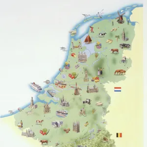
Pillow > Europe > Netherlands > Maps
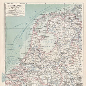
Pillow : MAP / NETHERLANDS 1827


![]()
Home Decor from Mary Evans Picture Library
MAP / NETHERLANDS 1827
Map of the Netherlands Date: 1827
Mary Evans Picture Library makes available wonderful images created for people to enjoy over the centuries
Media ID 20153871
© Bubblepunk
18"x18" (46x46cm) Pillow
18"x18" (46x46cm) Faux Suede Pillow with a plush soft feel. Your choice of image fills the front, with a stone colored faux suede back. Flat sewn concealed white zip.
Accessorise your space with decorative, soft pillows
Estimated Product Size is 45.7cm x 45.7cm (18" x 18")
These are individually made so all sizes are approximate
Artwork printed orientated as per the preview above, with landscape (horizontal) or portrait (vertical) orientation to match the source image.
FEATURES IN THESE COLLECTIONS
> Mary Evans Prints Online
> New Images July 2020
> Europe
> Netherlands
> Maps
> Europe
> Netherlands
> Posters
> Europe
> Netherlands
> Related Images
> Europe
> Related Images
> Maps and Charts
> Netherlands
> Maps and Charts
> Related Images
EDITORS COMMENTS
This map print, titled "Map of the Netherlands," dates back to the year 1827, making it an intriguing window into the past. The intricately detailed map showcases the geographical features of the Netherlands during this time, with its winding waterways, dense forests, and bustling cities. The map's vibrant colors and meticulous labeling provide a visual representation of the Netherlands' political and administrative divisions, including provinces, cities, and towns. The map was produced during a significant period in Dutch history. The Napoleonic Wars had ended just a few decades prior, and the Netherlands was in the midst of a period of political and economic transformation. This map offers a snapshot of the country's borders and territories during this time, providing valuable context for students of history and cartography. The map's scale and detail make it an essential resource for anyone interested in the Netherlands and its rich history. It offers a unique perspective on the country's geography, allowing us to trace the evolution of its borders and settlement patterns over time. Additionally, the map's aesthetic appeal makes it a beautiful addition to any home or office, serving as a conversation starter and a reminder of the fascinating history of the Netherlands and Europe as a whole. This map print is a testament to the art and science of cartography during the 19th century. It reflects the advances in mapmaking techniques and the growing importance of accurate and detailed maps for both practical and intellectual pursuits. Whether used for research, education, or decoration, this map of the Netherlands from 1827 is a valuable and intriguing addition to any collection.
MADE IN THE USA
Safe Shipping with 30 Day Money Back Guarantee
FREE PERSONALISATION*
We are proud to offer a range of customisation features including Personalised Captions, Color Filters and Picture Zoom Tools
SECURE PAYMENTS
We happily accept a wide range of payment options so you can pay for the things you need in the way that is most convenient for you
* Options may vary by product and licensing agreement. Zoomed Pictures can be adjusted in the Cart.