Fine Art Print > Europe > Netherlands > Maps
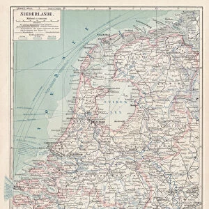
Fine Art Print : MAP / NETHERLANDS 1827


![]()
Fine Art Prints from Mary Evans Picture Library
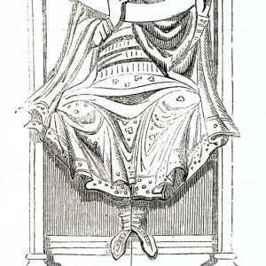
MAP / NETHERLANDS 1827
Map of the Netherlands Date: 1827
Mary Evans Picture Library makes available wonderful images created for people to enjoy over the centuries
Media ID 20153871
© Bubblepunk
20"x16" (+3" Border) Fine Art Print
Discover the captivating beauty of the past with our exquisite selection of Fine Art Prints from Media Storehouse, featuring this stunning 1827 Map of the Netherlands from Mary Evans Prints Online. This intricately detailed map transports you back in time, offering a glimpse into the historical geography and cartography of the Netherlands during the 19th century. Each print is meticulously reproduced using the highest quality materials, ensuring vibrant colors and sharp details that bring the image to life. Add a touch of history and sophistication to your home or office with this beautiful and unique addition to your collection.
20x16 image printed on 26x22 Fine Art Rag Paper with 3" (76mm) white border. Our Fine Art Prints are printed on 300gsm 100% acid free, PH neutral paper with archival properties. This printing method is used by museums and art collections to exhibit photographs and art reproductions.
Our fine art prints are high-quality prints made using a paper called Photo Rag. This 100% cotton rag fibre paper is known for its exceptional image sharpness, rich colors, and high level of detail, making it a popular choice for professional photographers and artists. Photo rag paper is our clear recommendation for a fine art paper print. If you can afford to spend more on a higher quality paper, then Photo Rag is our clear recommendation for a fine art paper print.
Estimated Image Size (if not cropped) is 40.6cm x 49cm (16" x 19.3")
Estimated Product Size is 55.9cm x 66cm (22" x 26")
These are individually made so all sizes are approximate
Artwork printed orientated as per the preview above, with portrait (vertical) orientation to match the source image.
FEATURES IN THESE COLLECTIONS
> Europe
> Netherlands
> Maps
> Europe
> Netherlands
> Posters
> Europe
> Netherlands
> Related Images
> Europe
> Related Images
> Maps and Charts
> Netherlands
> Maps and Charts
> Related Images
> Mary Evans Prints Online
> New Images July 2020
EDITORS COMMENTS
This map print, titled "Map of the Netherlands," dates back to the year 1827, making it an intriguing window into the past. The intricately detailed map showcases the geographical features of the Netherlands during this time, with its winding waterways, dense forests, and bustling cities. The map's vibrant colors and meticulous labeling provide a visual representation of the Netherlands' political and administrative divisions, including provinces, cities, and towns. The map was produced during a significant period in Dutch history. The Napoleonic Wars had ended just a few decades prior, and the Netherlands was in the midst of a period of political and economic transformation. This map offers a snapshot of the country's borders and territories during this time, providing valuable context for students of history and cartography. The map's scale and detail make it an essential resource for anyone interested in the Netherlands and its rich history. It offers a unique perspective on the country's geography, allowing us to trace the evolution of its borders and settlement patterns over time. Additionally, the map's aesthetic appeal makes it a beautiful addition to any home or office, serving as a conversation starter and a reminder of the fascinating history of the Netherlands and Europe as a whole. This map print is a testament to the art and science of cartography during the 19th century. It reflects the advances in mapmaking techniques and the growing importance of accurate and detailed maps for both practical and intellectual pursuits. Whether used for research, education, or decoration, this map of the Netherlands from 1827 is a valuable and intriguing addition to any collection.
MADE IN THE USA
Safe Shipping with 30 Day Money Back Guarantee
FREE PERSONALISATION*
We are proud to offer a range of customisation features including Personalised Captions, Color Filters and Picture Zoom Tools
SECURE PAYMENTS
We happily accept a wide range of payment options so you can pay for the things you need in the way that is most convenient for you
* Options may vary by product and licensing agreement. Zoomed Pictures can be adjusted in the Cart.