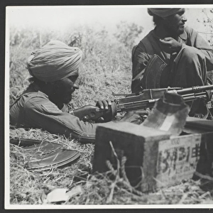
Pillow > Europe > France > Canton > Landes
Pillow : Defences of El Agheila, Libya, by G. H. Davis


![]()
Home Decor From Mary Evans Picture Library
Defences of El Agheila, Libya, by G. H. Davis
Where Rommel planned to make his final stand in Libya during the Second World War: El Agheila and its formidable natural defences. A map of the El Agheila terrain, naturally protected by a bottleneck entrance, salt marshes, sand dunes and deep wadis. Inset are photos of Mussolinis marble arch and El Agheila fort. Date: 1942
Mary Evans Picture Library makes available wonderful images created for people to enjoy over the centuries
Media ID 14133357
© Illustrated London News Ltd/Mary Evans
1942 Davis Deep Defences Dune Dunes Enemy Final Fort Gulf Libya Libyan Maps Marble Marsh Marshes Marshy Mussolini Photos Protected Rommel Salt Sand Stand Terrain Bottleneck
18"x18" (46x46cm) Pillow
18"x18" (46x46cm) Faux Suede Pillow with a plush soft feel. Your choice of image fills the front, with a stone colored faux suede back. Flat sewn concealed white zip.
Accessorise your space with decorative, soft pillows
Estimated Product Size is 45.7cm x 45.7cm (18" x 18")
These are individually made so all sizes are approximate
Artwork printed orientated as per the preview above, with landscape (horizontal) or portrait (vertical) orientation to match the source image.
FEATURES IN THESE COLLECTIONS
> Africa
> Libya
> Related Images
> Europe
> France
> Canton
> Landes
> Historic
> World War I and II
> Generals and leaders
> Maps and Charts
> Early Maps
> Maps and Charts
> Related Images
> Maps and Charts
> World
EDITORS COMMENTS
This evocative photograph print by G.H. Davis captures the natural defenses of El Agheila, a pivotal location in Libya during the Second World War. El Agheila, with its strategic position along the North African coast, was where Erwin Rommel, the German commander, planned to make his final stand against the Allied forces. The terrain of El Agheila is naturally fortified, with a narrow bottleneck entrance, expanses of salt marshes, towering sand dunes, and deep wadis. The map inset in the photograph illustrates the intricacies of the El Agheila landscape, highlighting the challenges faced by both the Axis and Allied forces during the Battle of Sidra. The Italian presence at El Agheila is marked by Mussolini's marble arch and the El Agheila fort, visible in the inset photos. These structures served as symbols of Italian power and control over the region. The Battle of El Agheila, fought in 1942, was a turning point in the North African Campaign, ultimately leading to the retreat of the Axis forces and the advance of the Allied forces towards Tunisia. This photograph print offers a glimpse into the historical significance of El Agheila and the strategic considerations that shaped the course of the Second World War in North Africa. The natural defenses of El Agheila, with its bottleneck entrance, salt marshes, sand dunes, and deep wadis, played a crucial role in the battle, making it a fascinating study in military history.
MADE IN THE USA
Safe Shipping with 30 Day Money Back Guarantee
FREE PERSONALISATION*
We are proud to offer a range of customisation features including Personalised Captions, Color Filters and Picture Zoom Tools
SECURE PAYMENTS
We happily accept a wide range of payment options so you can pay for the things you need in the way that is most convenient for you
* Options may vary by product and licensing agreement. Zoomed Pictures can be adjusted in the Basket.