Pillow : 1904, Clason Map or View of the Gilpin Colorado Gold and Mineral Belt, topography
![]()

Home Decor from Liszt Collection
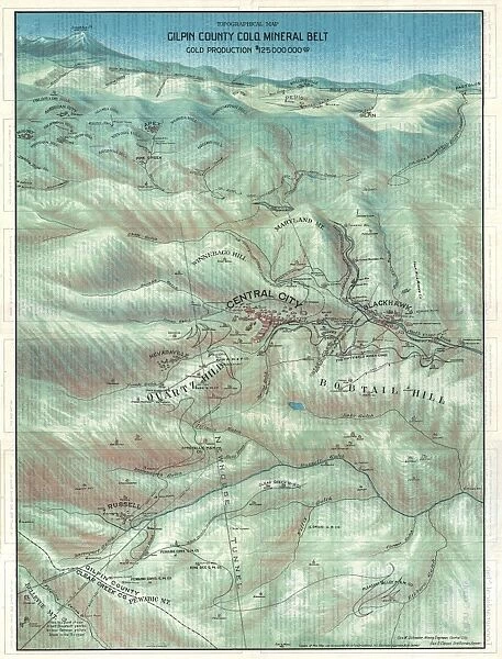
1904, Clason Map or View of the Gilpin Colorado Gold and Mineral Belt, topography
1904, Clason Map or View of the Gilpin Colorado Gold and Mineral Belt
Liszt Collection of nineteenth-century engravings and images to browse and enjoy
Media ID 14008135
© Artokoloro Quint Lox Limited
1904 Antique Map Latitude Longitude Mappa Mundi Old Antique Plan Old Antique View Ols Antique Map Rare Old Maps Topo
18"x18" (46x46cm) Pillow
18"x18" (46x46cm) Faux Suede Pillow with a plush soft feel. Your choice of image fills the front, with a stone colored faux suede back. Flat sewn concealed white zip.
Accessorise your space with decorative, soft pillows
Estimated Product Size is 45.7cm x 45.7cm (18" x 18")
These are individually made so all sizes are approximate
Artwork printed orientated as per the preview above, with landscape (horizontal) or portrait (vertical) orientation to match the source image.
EDITORS COMMENTS
This print showcases the remarkable "1904, Clason Map or View of the Gilpin Colorado Gold and Mineral Belt". A true testament to the artistry of cartography, this topographical masterpiece takes us back in time to an era when exploration and discovery were at their peak. The intricate details depicted on this vintage map transport us to a world where geography unfolds before our eyes. Every line, curve, and contour tells a story of the land's history, revealing its rich mineral resources and gold-laden terrain. This ancient relic serves as a reminder of the region's significant role in shaping Colorado's mining industry. Its decorative elements add a touch of elegance to its historical significance. The aged appearance evokes nostalgia for bygone eras when paper maps were cherished possessions that guided intrepid travelers through uncharted territories. With latitude and longitude grids meticulously plotted across its surface, this map served as an invaluable tool for navigation during those times. As we gaze upon this rare old map from the Liszt Collection, we are transported on a journey through time itself. It reminds us of humanity's insatiable thirst for knowledge and adventure while offering a glimpse into how our understanding of the world has evolved over centuries. Let this antique treasure ignite your imagination as you explore the wonders it holds within its delicate lines and faded hues.
MADE IN THE USA
Safe Shipping with 30 Day Money Back Guarantee
FREE PERSONALISATION*
We are proud to offer a range of customisation features including Personalised Captions, Color Filters and Picture Zoom Tools
SECURE PAYMENTS
We happily accept a wide range of payment options so you can pay for the things you need in the way that is most convenient for you
* Options may vary by product and licensing agreement. Zoomed Pictures can be adjusted in the Cart.


