Pillow > Historic > Ancient civilizations > Roman Empire > Roman art
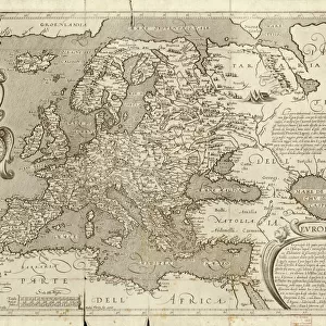
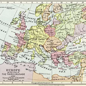
Pillow : MAP OF EUROPE, 12th CENTURY. A 19th century map of Europe as it was politically constituted in the


![]()
Home Decor From Granger
MAP OF EUROPE, 12th CENTURY. A 19th century map of Europe as it was politically constituted in the
MAP OF EUROPE, 12th CENTURY. A 19th century map of Europe as it was politically constituted in the 12th century
Granger holds millions of images spanning more than 25,000 years of world history, from before the Stone Age to the dawn of the Space Age
Media ID 6622533
12th Century Europe European Holy Roman Empire
18"x18" (46x46cm) Pillow
18"x18" (46x46cm) Faux Suede Pillow with a plush soft feel. Your choice of image fills the front, with a stone colored faux suede back. Flat sewn concealed white zip.
Accessorise your space with decorative, soft pillows
Estimated Product Size is 45.7cm x 45.7cm (18" x 18")
These are individually made so all sizes are approximate
Artwork printed orientated as per the preview above, with landscape (horizontal) or portrait (vertical) orientation to match the source image.
FEATURES IN THESE COLLECTIONS
> Arts
> Art Movements
> Medieval Art
> Arts
> Artists
> R
> Roman Roman
> Arts
> Landscape paintings
> Waterfall and river artworks
> River artworks
> Historic
> Ancient civilizations
> Roman Empire
> Roman art
> Maps and Charts
> Related Images
EDITORS COMMENTS
This 19th century print showcases a meticulously detailed map of Europe, transporting us back to the political landscape of the 12th century. The artist's intricate craftsmanship allows us to explore the medieval boundaries and territories that shaped this ancient continent. The map highlights various kingdoms, principalities, and empires that dominated Europe during this era. One prominent feature is the Holy Roman Empire, which sprawls across central Europe with its vast influence and power. Its borders are clearly defined, emphasizing its significance as a dominant force in European politics. Rivers meander gracefully throughout the map, serving as vital trade routes connecting different regions and facilitating cultural exchange between diverse communities. These waterways were essential for transportation and played a crucial role in shaping economic growth during this period. As we delve into this historical masterpiece, we can't help but marvel at how much has changed over time. This print serves as a reminder of our rich heritage and offers an opportunity to reflect on the immense transformations that have occurred since then. Whether you're an avid history enthusiast or simply appreciate artistry at its finest, this Granger Collection print is sure to captivate your imagination and transport you back in time to witness Europe's political landscape during the enchanting 12th century.
MADE IN THE USA
Safe Shipping with 30 Day Money Back Guarantee
FREE PERSONALISATION*
We are proud to offer a range of customisation features including Personalised Captions, Color Filters and Picture Zoom Tools
SECURE PAYMENTS
We happily accept a wide range of payment options so you can pay for the things you need in the way that is most convenient for you
* Options may vary by product and licensing agreement. Zoomed Pictures can be adjusted in the Basket.