Pillow > Europe > France > Maps
Pillow : Map of North France 1896


![]()
Home Decor from Fine Art Storehouse
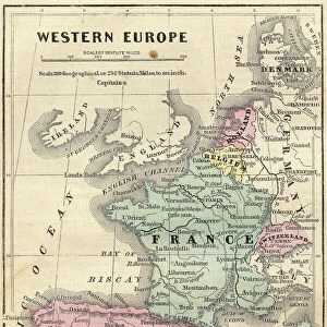
Map of North France 1896
Andres Allgemeiner Handatlas - Bielefeld und Leipzig 1896
Unleash your creativity and transform your space into a visual masterpiece!
THEPALMER
Media ID 18356795
18"x18" (46x46cm) Pillow
18"x18" (46x46cm) Faux Suede Pillow with a plush soft feel. Your choice of image fills the front, with a stone colored faux suede back. Flat sewn concealed white zip.
Accessorise your space with decorative, soft pillows
Estimated Product Size is 45.7cm x 45.7cm (18" x 18")
These are individually made so all sizes are approximate
Artwork printed orientated as per the preview above, with landscape (horizontal) or portrait (vertical) orientation to match the source image.
FEATURES IN THESE COLLECTIONS
> Fine Art Storehouse
> Map
> Historical Maps
> Maps and Charts
> Related Images
EDITORS COMMENTS
In this photo print, titled "Map of North France 1896" we are transported back in time to the late 19th century. The map, sourced from Andres Allgemeiner Handatlas - Bielefeld und Leipzig 1896, offers a fascinating glimpse into the geographical landscape of Northern France during that era. With intricate details and precise cartography, this vintage map showcases the region's cities, towns, rivers, and topographical features. It serves as a historical document that not only provides navigational information but also reveals insights into the political boundaries and cultural heritage of the time. The sepia-toned hues lend an air of nostalgia to this artwork by THEPALMER from Fine Art Storehouse. As we examine each line and contour on this meticulously crafted piece, we can't help but marvel at how much has changed over the past century. This print becomes a portal through which we can explore history and appreciate how our world has evolved. Whether displayed in a study or living room, this Map of North France 1896 is sure to spark curiosity and conversation among admirers. Its timeless appeal transcends generations as it invites us to delve into the past while appreciating its artistic value in today's context.
MADE IN THE USA
Safe Shipping with 30 Day Money Back Guarantee
FREE PERSONALISATION*
We are proud to offer a range of customisation features including Personalised Captions, Color Filters and Picture Zoom Tools
SECURE PAYMENTS
We happily accept a wide range of payment options so you can pay for the things you need in the way that is most convenient for you
* Options may vary by product and licensing agreement. Zoomed Pictures can be adjusted in the Cart.