Pillow > Asia > Iran > Maps
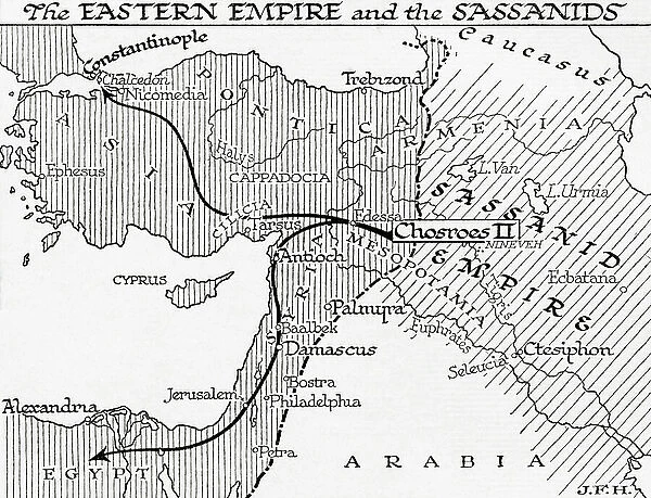
Pillow : Map of the Eastern Empire and the Sassanids, 7th century. (print)
![]()

Home Decor From Fine Art Finder
Map of the Eastern Empire and the Sassanids, 7th century. (print)
7420040 Map of the Eastern Empire and the Sassanids, 7th century. (print); (add.info.: Map of the Eastern Empire and the Sassanids, 7th century. From the book Outline of History by H.G. Wells, published 1920.); Photo © Ken Welsh. All rights reserved 2024
Media ID 38287588
© © Ken Welsh. All rights reserved 2024 / Bridgeman Images
7 Century 7th Century 7th Century Century Ageing C7th Chart Diagram Graph Iran Iranian Iranians Persia Persians Run Down Seventh Century Seventh Century Ad Vii Century Viith Century Geographer
18"x18" (46x46cm) Pillow
18"x18" (46x46cm) Faux Suede Pillow with a plush soft feel. Your choice of image fills the front, with a stone colored faux suede back. Flat sewn concealed white zip.
Accessorise your space with decorative, soft pillows
Estimated Product Size is 45.7cm x 45.7cm (18" x 18")
These are individually made so all sizes are approximate
Artwork printed orientated as per the preview above, with landscape (horizontal) or portrait (vertical) orientation to match the source image.
FEATURES IN THESE COLLECTIONS
> Asia
> Iran
> Related Images
> Maps and Charts
> Early Maps
> Maps and Charts
> Related Images
EDITORS COMMENTS
This print of the Map of the Eastern Empire and the Sassanids from the 7th century is a true testament to the intricate artistry of cartography in ancient times. The detailed engraving showcases the vast territories of Iran, also known as Persia, during this pivotal period in history.
As we gaze upon this aged depiction, we are transported back to a time when empires clashed and civilizations flourished. The borders delineated on this map tell stories of conquests and alliances, offering us a glimpse into the geopolitical landscape of the Middle East in centuries past.
The black and white contrast adds a sense of nostalgia to this historical artifact, reminding us of its antiquity and significance. Each line drawn by the skilled geographer captures not only physical boundaries but also cultural exchanges that shaped these regions for generations to come.
This print is more than just a visual representation; it is a window into an era filled with intrigue and power struggles. It serves as a reminder of how far we have come as societies while honoring those who meticulously crafted such maps for future generations to study and appreciate.
In owning this piece, one holds not just an image but a piece of history that continues to resonate with us today.
MADE IN THE USA
Safe Shipping with 30 Day Money Back Guarantee
FREE PERSONALISATION*
We are proud to offer a range of customisation features including Personalised Captions, Color Filters and Picture Zoom Tools
SECURE PAYMENTS
We happily accept a wide range of payment options so you can pay for the things you need in the way that is most convenient for you
* Options may vary by product and licensing agreement. Zoomed Pictures can be adjusted in the Basket.


