Photographic Print > Maps and Charts > Early Maps
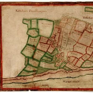
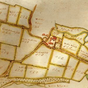
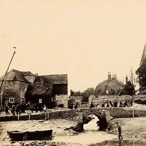
Photographic Print : Map of Westbourne village, 1640


![]()
Photo Prints from West Sussex County Council
Map of Westbourne village, 1640
Additional Manuscript Collection
West Sussex Record Office Ref No: Add Ms 2856
West Sussex County Council Record Office contains a fascinating history of the county of West Sussex, England
Media ID 7915114
© West Sussex County Council - All Rights Reserved
Fields Historical Mapping Houses
10"x8" Photo Print
Discover the rich history of Westbourne Village with our exquisite Media Storehouse Photographic Print of a rare map dating back to 1640. This stunning piece, sourced from the West Sussex County Council Additional Manuscript Collection (Ref No: Add Ms 2856), offers a unique glimpse into the past. With intricate details and vibrant colors, this print makes a captivating addition to any home or office, transporting you back in time. Bring history to life with this beautiful and authentic piece from Media Storehouse.
Photo prints are produced on Kodak professional photo paper resulting in timeless and breath-taking prints which are also ideal for framing. The colors produced are rich and vivid, with accurate blacks and pristine whites, resulting in prints that are truly timeless and magnificent. Whether you're looking to display your prints in your home, office, or gallery, our range of photographic prints are sure to impress. Dimensions refers to the size of the paper in inches.
Our Photo Prints are in a large range of sizes and are printed on Archival Quality Paper for excellent colour reproduction and longevity. They are ideal for framing (our Framed Prints use these) at a reasonable cost. Alternatives include cheaper Poster Prints and higher quality Fine Art Paper, the choice of which is largely dependant on your budget.
Estimated Image Size (if not cropped) is 25.4cm x 18.5cm (10" x 7.3")
Estimated Product Size is 25.4cm x 20.3cm (10" x 8")
These are individually made so all sizes are approximate
Artwork printed orientated as per the preview above, with landscape (horizontal) orientation to match the source image.
FEATURES IN THESE COLLECTIONS
> Europe
> United Kingdom
> England
> Sussex
> Related Images
> Europe
> United Kingdom
> England
> West Sussex
> Related Images
> Maps and Charts
> Early Maps
> Maps and Charts
> Related Images
> West Sussex County Council
> West Sussex Record Office
> Additional Manuscript
EDITORS COMMENTS
This print showcases a remarkable piece of history, the "Map of Westbourne village, 1640". Preserved within the Additional Manuscript Collection at the West Sussex Record Office, this ancient map offers a mesmerizing glimpse into the past. With its intricate details and meticulous craftsmanship, this old map vividly depicts the landscape of Westbourne village during a bygone era. Every field and house is meticulously illustrated, allowing us to explore how this charming village once appeared centuries ago. As we delve into its historical mapping, we are transported back in time to an age where life was simpler yet filled with unique charm. The Map of Westbourne village serves as a testament to our rich heritage and provides invaluable insights into how communities were structured in the seventeenth century. It allows us to trace the evolution of land use patterns over time and understand how these changes have shaped our present-day surroundings. As we admire this stunning print from West Sussex County Council's collection, let us appreciate not only its aesthetic appeal but also its significance as a valuable historical document. This image invites us to embark on an enlightening journey through time while fostering a deep sense of connection with those who came before us
MADE IN THE USA
Safe Shipping with 30 Day Money Back Guarantee
FREE PERSONALISATION*
We are proud to offer a range of customisation features including Personalised Captions, Color Filters and Picture Zoom Tools
SECURE PAYMENTS
We happily accept a wide range of payment options so you can pay for the things you need in the way that is most convenient for you
* Options may vary by product and licensing agreement. Zoomed Pictures can be adjusted in the Cart.