Framed Print > Maps and Charts > Early Maps
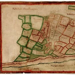
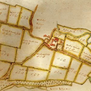
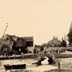
Framed Print : Map of Westbourne village, 1640


![]()
Framed Photos from West Sussex County Council
Map of Westbourne village, 1640
Additional Manuscript Collection
West Sussex Record Office Ref No: Add Ms 2856
West Sussex County Council Record Office contains a fascinating history of the county of West Sussex, England
Media ID 7915114
© West Sussex County Council - All Rights Reserved
Fields Historical Mapping Houses
12"x10" Modern Frame
Step back in time with our exquisite Framed Prints from Media Storehouse. This particular piece showcases a captivating Map of Westbourne Village, dating back to 1640. Sourced from the West Sussex County Council Additional Manuscript Collection (Ref No: Add Ms 2856), this historical map adds a touch of antiquity and character to any space. The intricate details bring the history of Westbourne Village to life, making it a fascinating conversation starter. Order now and bring a piece of the past into your home or office.
10x8 Print in an MDF Wooden Frame with 180 gsm Satin Finish Paper. Glazed using shatter proof thin plexi glass. Frame thickness is 1 inch and depth 0.75 inch. Fluted cardboard backing held with clips. Supplied ready to hang with sawtooth hanger and rubber bumpers. Spot clean with a damp cloth. Packaged foam wrapped in a card.
Contemporary Framed and Mounted Prints - Professionally Made and Ready to Hang
Estimated Image Size (if not cropped) is 25.4cm x 25.4cm (10" x 10")
Estimated Product Size is 30.5cm x 25.4cm (12" x 10")
These are individually made so all sizes are approximate
Artwork printed orientated as per the preview above, with landscape (horizontal) or portrait (vertical) orientation to match the source image.
FEATURES IN THESE COLLECTIONS
> Europe
> United Kingdom
> England
> Sussex
> Related Images
> Europe
> United Kingdom
> England
> West Sussex
> Related Images
> Maps and Charts
> Early Maps
> Maps and Charts
> Related Images
> West Sussex County Council
> West Sussex Record Office
> Additional Manuscript
EDITORS COMMENTS
This print showcases a remarkable piece of history, the "Map of Westbourne village, 1640". Preserved within the Additional Manuscript Collection at the West Sussex Record Office, this ancient map offers a mesmerizing glimpse into the past. With its intricate details and meticulous craftsmanship, this old map vividly depicts the landscape of Westbourne village during a bygone era. Every field and house is meticulously illustrated, allowing us to explore how this charming village once appeared centuries ago. As we delve into its historical mapping, we are transported back in time to an age where life was simpler yet filled with unique charm. The Map of Westbourne village serves as a testament to our rich heritage and provides invaluable insights into how communities were structured in the seventeenth century. It allows us to trace the evolution of land use patterns over time and understand how these changes have shaped our present-day surroundings. As we admire this stunning print from West Sussex County Council's collection, let us appreciate not only its aesthetic appeal but also its significance as a valuable historical document. This image invites us to embark on an enlightening journey through time while fostering a deep sense of connection with those who came before us
MADE IN THE USA
Safe Shipping with 30 Day Money Back Guarantee
FREE PERSONALISATION*
We are proud to offer a range of customisation features including Personalised Captions, Color Filters and Picture Zoom Tools
SECURE PAYMENTS
We happily accept a wide range of payment options so you can pay for the things you need in the way that is most convenient for you
* Options may vary by product and licensing agreement. Zoomed Pictures can be adjusted in the Cart.