Photographic Print > Europe > United Kingdom > England > London > Museums > Science Museum
Photographic Print : William Smiths Geological Map

![]()
Photo Prints From Science Photo Library
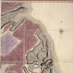
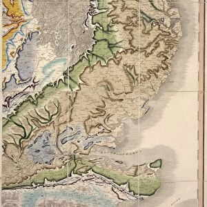
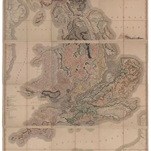
William Smiths Geological Map
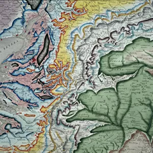
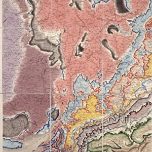
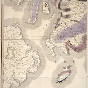
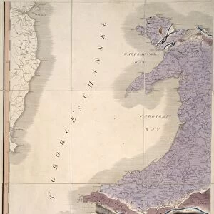
William Smiths Geological Map. Fig. 9 from Delineation of Strata of England and Wales (1815) by William Smith
Science Photo Library features Science and Medical images including photos and illustrations
Media ID 9206571
© NATURAL HISTORY MUSEUM, LONDON/SCIENCE PHOTO LIBRARY
Geological Great Britain Rock Smith Strata Stratification Type Wales William Smith 1769 1839 Geological Map
12"x8" Photo Print
Discover the rich history of geology with our stunning selection of photographic prints from the Media Storehouse. This particular print showcases a piece of scientific history with William Smith's iconic "Delineation of Strata of England and Wales" map from 1815, held at the Natural History Museum in London. Published by Science Photo Library, this print is a beautiful representation of Smith's groundbreaking work, which revolutionized the understanding of the Earth's geological structure. Bring a piece of geological history into your home or office and start a conversation with this captivating print.
Photo prints are produced on Kodak professional photo paper resulting in timeless and breath-taking prints which are also ideal for framing. The colors produced are rich and vivid, with accurate blacks and pristine whites, resulting in prints that are truly timeless and magnificent. Whether you're looking to display your prints in your home, office, or gallery, our range of photographic prints are sure to impress. Dimensions refers to the size of the paper in inches.
Our Photo Prints are in a large range of sizes and are printed on Archival Quality Paper for excellent colour reproduction and longevity. They are ideal for framing (our Framed Prints use these) at a reasonable cost. Alternatives include cheaper Poster Prints and higher quality Fine Art Paper, the choice of which is largely dependant on your budget.
Estimated Image Size (if not cropped) is 17.7cm x 30.4cm (7" x 12")
Estimated Product Size is 20.3cm x 30.5cm (8" x 12")
These are individually made so all sizes are approximate
Artwork printed orientated as per the preview above, with portrait (vertical) orientation to match the source image.
FEATURES IN THESE COLLECTIONS
> Europe
> United Kingdom
> England
> London
> Museums
> British Library
> Europe
> United Kingdom
> England
> London
> Museums
> British Museum
> Europe
> United Kingdom
> England
> London
> Museums
> Natural History Museum
> Europe
> United Kingdom
> England
> London
> Museums
> Science Museum
> Europe
> United Kingdom
> England
> London
> Sights
> British Museum
> Europe
> United Kingdom
> England
> Maps
> Europe
> United Kingdom
> Maps
> Europe
> United Kingdom
> Wales
> Maps
> Europe
> United Kingdom
> Wales
> Posters
> Maps and Charts
> Geological Map
EDITORS COMMENTS
This print showcases the iconic "William Smiths Geological Map" created by William Smith in 1815. The map, depicted in Figure 9 of his renowned publication "Delineation of Strata of England and Wales" is a groundbreaking representation of the geological formations found throughout Great Britain. The image captures the intricate details and vibrant colors present on this historical map, which has become an invaluable resource for understanding the geology of not only England and Wales but also Europe as a whole. William Smith's meticulous work revolutionized the field of geology by introducing stratification principles that laid the foundation for modern geological mapping. Displayed proudly at the Natural History Museum in London, this print serves as a testament to both Smith's scientific brilliance and artistic skill. Each type of rock and stratum is meticulously illustrated, allowing viewers to appreciate the complexity and diversity within Earth's layers. As we gaze upon this remarkable piece, we are reminded of how one individual's dedication can shape our understanding of our planet's history. This photograph invites us to explore not only the geological wonders captured on this map but also to reflect on how scientific discoveries continue to transform our knowledge about Earth's past.
MADE IN THE USA
Safe Shipping with 30 Day Money Back Guarantee
FREE PERSONALISATION*
We are proud to offer a range of customisation features including Personalised Captions, Color Filters and Picture Zoom Tools
SECURE PAYMENTS
We happily accept a wide range of payment options so you can pay for the things you need in the way that is most convenient for you
* Options may vary by product and licensing agreement. Zoomed Pictures can be adjusted in the Basket.