Photographic Print > North America > Mexico > Maps
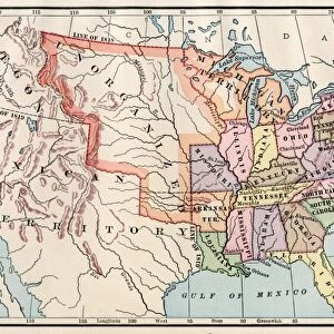
Photographic Print : United States map in 1830


![]()
Photo Prints From North Wind
United States map in 1830
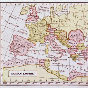
Territories of the United States in 1830.
Printed color lithograph
North Wind Picture Archives brings history to life with stock images and hand-colored illustrations
Media ID 5877430
© North Wind Picture Archives
1830s America Frontier Mexico Oregon Oregon Territory State Territory 1830
10"x8" Photo Print
Step back in time with our exclusive Media Storehouse United States Map Print from North Wind Picture Archives. This captivating, printed color lithograph depicts the United States as it existed in 1830, a fascinating representation of the country's territorial expansion. Explore the territories that once were, and add a touch of history to your home or office decor. Each print is carefully produced using high-quality materials to ensure long-lasting vibrancy and detail. Bring history to life with this intriguing and educational addition to your collection. Order yours today and travel through time with every glance.
Photo prints are produced on Kodak professional photo paper resulting in timeless and breath-taking prints which are also ideal for framing. The colors produced are rich and vivid, with accurate blacks and pristine whites, resulting in prints that are truly timeless and magnificent. Whether you're looking to display your prints in your home, office, or gallery, our range of photographic prints are sure to impress. Dimensions refers to the size of the paper in inches.
Our Photo Prints are in a large range of sizes and are printed on Archival Quality Paper for excellent colour reproduction and longevity. They are ideal for framing (our Framed Prints use these) at a reasonable cost. Alternatives include cheaper Poster Prints and higher quality Fine Art Paper, the choice of which is largely dependant on your budget.
Estimated Image Size (if not cropped) is 25.4cm x 18.6cm (10" x 7.3")
Estimated Product Size is 25.4cm x 20.3cm (10" x 8")
These are individually made so all sizes are approximate
Artwork printed orientated as per the preview above, with landscape (horizontal) orientation to match the source image.
FEATURES IN THESE COLLECTIONS
> North Wind Picture Archives
> American history
> North Wind Picture Archives
> Maps
> Maps and Charts
> Related Images
> North America
> Mexico
> Maps
> North America
> Mexico
> Related Images
EDITORS COMMENTS
This vintage print showcases the United States map in 1830, providing a glimpse into the nation's rich history and territorial expansion. The intricate details of this printed color lithograph transport us back to a time when America was still in its formative years, on the cusp of significant changes. The map highlights not only the states that existed at that time but also the territories that were yet to be fully incorporated into the Union. It serves as a visual representation of America's frontier spirit and manifest destiny, with vast unorganized public lands waiting to be explored and settled. One cannot help but marvel at how different this map appears compared to modern-day cartography. The Oregon Territory looms large, stretching from present-day Oregon all the way up into Canada. This depiction reminds us of an era when borders were fluid and contested, reflecting ongoing negotiations between Mexico and America over land claims. As we study this historic illustration, it becomes clear that it is more than just a geographical document; it is a work of art capturing an essential chapter in American history. It evokes feelings of nostalgia for simpler times while reminding us of our nation's relentless pursuit of progress. Whether displayed in homes or educational institutions, this North Wind Picture Archives print offers viewers an opportunity to connect with their heritage and appreciate how far our great country has come since those early days in 1830s America.
MADE IN THE USA
Safe Shipping with 30 Day Money Back Guarantee
FREE PERSONALISATION*
We are proud to offer a range of customisation features including Personalised Captions, Color Filters and Picture Zoom Tools
SECURE PAYMENTS
We happily accept a wide range of payment options so you can pay for the things you need in the way that is most convenient for you
* Options may vary by product and licensing agreement. Zoomed Pictures can be adjusted in the Basket.