Framed Print > North America > Mexico > Maps
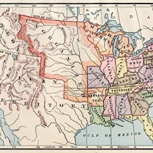
Framed Print : United States map in 1830


![]()
Framed Photos From North Wind
United States map in 1830
Territories of the United States in 1830.
Printed color lithograph
North Wind Picture Archives brings history to life with stock images and hand-colored illustrations
Media ID 5877430
© North Wind Picture Archives
1830s America Frontier Mexico Oregon Oregon Territory State Territory 1830
12"x10" Modern Frame
Step back in time with our stunning Framed Print from Media Storehouse, featuring an intriguing United States map from 1830. This captivating print, sourced from North Wind Picture Archives, showcases the Territories of the United States in vibrant color lithograph. Perfect for history enthusiasts, educators, or anyone who appreciates the beauty of vintage maps, this framed print adds a touch of timeless charm to any room in your home or office. Bring the past to life with this unique and captivating addition to your decor. Order now and experience history in a whole new way!
10x8 Print in an MDF Wooden Frame with 180 gsm Satin Finish Paper. Glazed using shatter proof thin plexi glass. Frame thickness is 1 inch and depth 0.75 inch. Fluted cardboard backing held with clips. Supplied ready to hang with sawtooth hanger and rubber bumpers. Spot clean with a damp cloth. Packaged foam wrapped in a card.
Contemporary Framed and Mounted Prints - Professionally Made and Ready to Hang
Estimated Image Size (if not cropped) is 25.4cm x 25.4cm (10" x 10")
Estimated Product Size is 30.5cm x 25.4cm (12" x 10")
These are individually made so all sizes are approximate
Artwork printed orientated as per the preview above, with landscape (horizontal) or portrait (vertical) orientation to match the source image.
FEATURES IN THESE COLLECTIONS
> Maps and Charts
> Related Images
> North America
> Mexico
> Maps
> North America
> Mexico
> Related Images
EDITORS COMMENTS
This vintage print showcases the United States map in 1830, providing a glimpse into the nation's rich history and territorial expansion. The intricate details of this printed color lithograph transport us back to a time when America was still in its formative years, on the cusp of significant changes. The map highlights not only the states that existed at that time but also the territories that were yet to be fully incorporated into the Union. It serves as a visual representation of America's frontier spirit and manifest destiny, with vast unorganized public lands waiting to be explored and settled. One cannot help but marvel at how different this map appears compared to modern-day cartography. The Oregon Territory looms large, stretching from present-day Oregon all the way up into Canada. This depiction reminds us of an era when borders were fluid and contested, reflecting ongoing negotiations between Mexico and America over land claims. As we study this historic illustration, it becomes clear that it is more than just a geographical document; it is a work of art capturing an essential chapter in American history. It evokes feelings of nostalgia for simpler times while reminding us of our nation's relentless pursuit of progress. Whether displayed in homes or educational institutions, this North Wind Picture Archives print offers viewers an opportunity to connect with their heritage and appreciate how far our great country has come since those early days in 1830s America.
MADE IN THE USA
Safe Shipping with 30 Day Money Back Guarantee
FREE PERSONALISATION*
We are proud to offer a range of customisation features including Personalised Captions, Color Filters and Picture Zoom Tools
SECURE PAYMENTS
We happily accept a wide range of payment options so you can pay for the things you need in the way that is most convenient for you
* Options may vary by product and licensing agreement. Zoomed Pictures can be adjusted in the Basket.