Photographic Print > Historic > Ancient civilizations > Ancient Greece > Greek history
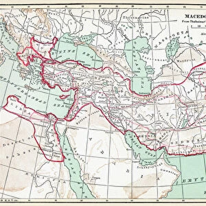
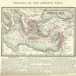
Photographic Print : Map of the Macedonian and Thracian Empire


![]()
Photo Prints from Mary Evans Picture Library
Map of the Macedonian and Thracian Empire
Map of the Macedonian and Thracian Empire. Date: 1808
Mary Evans Picture Library makes available wonderful images created for people to enjoy over the centuries
Media ID 11575337
© Mary Evans / Grenville Collins Postcard Collection
1808 Aegean Balkan Balkans Byzantium Chart Dacia Epirus Illyria Ionian Macedonia Macedonian Maps Thracian
10"x8" Photo Print
Introducing the captivating "Map of the Macedonian and Thracian Empire" from our Media Storehouse collection of photographic prints. This exquisite antique map, dating back to 1808, was sourced from Mary Evans Prints Online. With intricate details and rich historical significance, this print offers a glimpse into the past, showcasing the extent of the Macedonian and Thracian Empire during its prime. Ideal for history enthusiasts, educators, or anyone with an appreciation for the art and detail of historical maps, this print makes for a stunning addition to any wall. Bring history to life in your home or office with the Media Storehouse range of photographic prints.
Photo prints are produced on Kodak professional photo paper resulting in timeless and breath-taking prints which are also ideal for framing. The colors produced are rich and vivid, with accurate blacks and pristine whites, resulting in prints that are truly timeless and magnificent. Whether you're looking to display your prints in your home, office, or gallery, our range of photographic prints are sure to impress. Dimensions refers to the size of the paper in inches.
Our Photo Prints are in a large range of sizes and are printed on Archival Quality Paper for excellent colour reproduction and longevity. They are ideal for framing (our Framed Prints use these) at a reasonable cost. Alternatives include cheaper Poster Prints and higher quality Fine Art Paper, the choice of which is largely dependant on your budget.
Estimated Product Size is 25.4cm x 20.3cm (10" x 8")
These are individually made so all sizes are approximate
Artwork printed orientated as per the preview above, with landscape (horizontal) or portrait (vertical) orientation to match the source image.
FEATURES IN THESE COLLECTIONS
> Europe
> Greece
> Related Images
> Europe
> Macedonia
> Posters
> Europe
> Macedonia
> Related Images
> Europe
> Related Images
> Historic
> Ancient civilizations
> Ancient Greece
> Greek history
> Maps and Charts
> Early Maps
EDITORS COMMENTS
This map print, dated 1808, offers a glimpse into the rich historical tapestry of the Macedonian and Thracian Empire, a vast territory that once stretched across Central Europe and the Balkan Peninsula. The map meticulously delineates the borders of ancient civilizations, including Macedonia, Thrace, Epirus, Thessalia, Illyrium, Dacia, and more. Macedonia, located in the northern part of the map, was a significant ancient kingdom that flourished from the 8th to the 14th centuries BC. It was renowned for its powerful rulers, such as Alexander the Great, who expanded the Macedonian Empire to include much of the ancient world. Thrace, situated to the east, was a diverse region inhabited by various tribes, including the Thracians, who were known for their warrior culture and gold mining. Thessalia, to the west, was a fertile plain that was a center of Greek civilization. Illyrium, to the south, was a region inhabited by the Illyrians, who were known for their resistance to Roman rule. Dacia, located north of the Danube River, was a powerful and prosperous kingdom that was annexed by the Romans in AD 106. The map also highlights key geographical features, such as the Aegean Sea, the Ionian Sea, and the Byzantium Straits. These bodies of water played crucial roles in the economic and cultural exchange between the various civilizations of the region. This map is an invaluable resource for anyone interested in ancient history, particularly the history of Central Europe and the Balkans. It provides a fascinating glimpse into the complex and interconnected world of ancient civilizations and offers a reminder of the rich cultural heritage that continues to shape our world today.
MADE IN THE USA
Safe Shipping with 30 Day Money Back Guarantee
FREE PERSONALISATION*
We are proud to offer a range of customisation features including Personalised Captions, Color Filters and Picture Zoom Tools
SECURE PAYMENTS
We happily accept a wide range of payment options so you can pay for the things you need in the way that is most convenient for you
* Options may vary by product and licensing agreement. Zoomed Pictures can be adjusted in the Cart.