Photographic Print > Europe > Netherlands > Maps
Photographic Print : Map / France / Belgium / Nethe


![]()
Photo Prints from Mary Evans Picture Library
Map / France / Belgium / Nethe
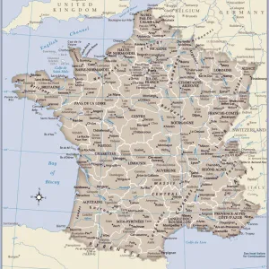
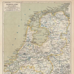
Map of France, Belgium and the Netherlands
Mary Evans Picture Library makes available wonderful images created for people to enjoy over the centuries
Media ID 608787
© Mary Evans Picture Library 2015 - https://copyrighthub.org/s0/hub1/creation/maryevans/MaryEvansPictureID/10113948
10"x8" Photo Print
Discover the captivating beauty of Europe with our exquisite selection of photographic prints from Mary Evans Picture Library. This particular print, titled "Map / France / Belgium / Netherlands" by Mary Evans, showcases an intricately detailed map of France, Belgium, and the Netherlands. Each line and border is rendered with stunning clarity, inviting you to explore the rich history and cultural connections between these three neighboring countries. A beautiful addition to any home or office, this photographic print is not only a functional piece, but also a work of art that is sure to inspire and delight. Order yours today and bring a touch of European charm into your space.
Photo prints are produced on Kodak professional photo paper resulting in timeless and breath-taking prints which are also ideal for framing. The colors produced are rich and vivid, with accurate blacks and pristine whites, resulting in prints that are truly timeless and magnificent. Whether you're looking to display your prints in your home, office, or gallery, our range of photographic prints are sure to impress. Dimensions refers to the size of the paper in inches.
Our Photo Prints are in a large range of sizes and are printed on Archival Quality Paper for excellent colour reproduction and longevity. They are ideal for framing (our Framed Prints use these) at a reasonable cost. Alternatives include cheaper Poster Prints and higher quality Fine Art Paper, the choice of which is largely dependant on your budget.
Estimated Product Size is 20.3cm x 25.4cm (8" x 10")
These are individually made so all sizes are approximate
Artwork printed orientated as per the preview above, with landscape (horizontal) or portrait (vertical) orientation to match the source image.
FEATURES IN THESE COLLECTIONS
> Europe
> Belgium
> Related Images
> Europe
> Netherlands
> Maps
> Europe
> Netherlands
> Posters
> Europe
> Netherlands
> Related Images
> Europe
> Related Images
> Maps and Charts
> Early Maps
EDITORS COMMENTS
This early 20th century map print depicts the territories of France, Belgium, and the Netherlands in Europe. The intricate details of the map show the political boundaries of these countries during a significant period in European history. France, located in the western part of the map, is shown in its full extent, including its metropolitan regions and overseas territories. The map highlights the major cities of France, such as Paris, Marseille, Bordeaux, and Lyon, as well as significant geographical features like the Alps, the Massif Central, and the Rhine River. To the north of France lies Belgium, a small but historically important country. The map reveals the division of Belgium into its three regions: Flanders in the north, Wallonia in the south, and Brussels, the capital city, in the center. The map also shows the major rivers of Belgium, including the Meuse, the Scheldt, and the Rhine. The Netherlands, located to the northeast of Belgium, is shown in its full extent, including the provinces of North and South Holland, Zeeland, and Friesland. The map highlights the major cities of the Netherlands, such as Amsterdam, Rotterdam, and The Hague, as well as significant geographical features like the North Sea, the Rhine River, and the Wadden Sea. This map offers a fascinating glimpse into the political and geographical landscape of Europe during the early 20th century, a time of significant change and development in the history of France, Belgium, and the Netherlands. The intricate details of the map provide valuable insights into the historical context of this region and offer a visual representation of the complex interconnections between these countries and their shared history.
MADE IN THE USA
Safe Shipping with 30 Day Money Back Guarantee
FREE PERSONALISATION*
We are proud to offer a range of customisation features including Personalised Captions, Color Filters and Picture Zoom Tools
SECURE PAYMENTS
We happily accept a wide range of payment options so you can pay for the things you need in the way that is most convenient for you
* Options may vary by product and licensing agreement. Zoomed Pictures can be adjusted in the Cart.