Metal Print > Europe > Netherlands > Maps
Metal Print : Map / France / Belgium / Nethe


![]()
Metal Prints from Mary Evans Picture Library
Map / France / Belgium / Nethe
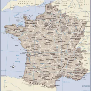
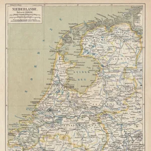
Map of France, Belgium and the Netherlands
Mary Evans Picture Library makes available wonderful images created for people to enjoy over the centuries
Media ID 608787
© Mary Evans Picture Library 2015 - https://copyrighthub.org/s0/hub1/creation/maryevans/MaryEvansPictureID/10113948
16"x20" (51x41cm) Metal Print
Bring the beauty of history into your home with our Media Storehouse Metal Prints featuring the captivating Map of France, Belgium, and the Netherlands from Mary Evans Picture Library at Mary Evans Prints Online. This intricately detailed map, showcasing the borders and territories of France, Belgium, and the Netherlands, is meticulously transferred onto a high-quality metal surface for a vibrant, long-lasting display. The sleek, modern design of the metal print adds a unique and stylish touch to any room, making it an excellent addition to your decor. Explore the rich history and culture of Europe with this stunning piece of art.
Made with durable metal and luxurious printing techniques, our metal photo prints go beyond traditional canvases, adding a cool, modern touch to your space. Wall mount on back. Eco-friendly 100% post-consumer recycled ChromaLuxe aluminum surface. The thickness of the print is 0.045". Featuring a Scratch-resistant surface and Rounded corners. Backing hangers are attached to the back of the print and float the print 1/2-inch off the wall when hung, the choice of hanger may vary depending on size and International orders will come with Float Mount hangers only. Finished with a brilliant white high gloss surface for unsurpassed detail and vibrance. Printed using Dye-Sublimation and for best care we recommend a non-ammonia glass cleaner, water, or isopropyl (rubbing) alcohol to prevent harming the print surface. We recommend using a clean, lint-free cloth to wipe off the print. The ultra-hard surface is scratch-resistant, waterproof and weatherproof. Avoid direct sunlight exposure.
Made with durable metal and luxurious printing techniques, metal prints bring images to life and add a modern touch to any space
Estimated Image Size (if not cropped) is 40.6cm x 50.8cm (16" x 20")
Estimated Product Size is 41.2cm x 51.4cm (16.2" x 20.2")
These are individually made so all sizes are approximate
Artwork printed orientated as per the preview above, with portrait (vertical) orientation to match the source image.
FEATURES IN THESE COLLECTIONS
> Europe
> Belgium
> Related Images
> Europe
> Netherlands
> Maps
> Europe
> Netherlands
> Posters
> Europe
> Netherlands
> Related Images
> Europe
> Related Images
> Maps and Charts
> Early Maps
EDITORS COMMENTS
This early 20th century map print depicts the territories of France, Belgium, and the Netherlands in Europe. The intricate details of the map show the political boundaries of these countries during a significant period in European history. France, located in the western part of the map, is shown in its full extent, including its metropolitan regions and overseas territories. The map highlights the major cities of France, such as Paris, Marseille, Bordeaux, and Lyon, as well as significant geographical features like the Alps, the Massif Central, and the Rhine River. To the north of France lies Belgium, a small but historically important country. The map reveals the division of Belgium into its three regions: Flanders in the north, Wallonia in the south, and Brussels, the capital city, in the center. The map also shows the major rivers of Belgium, including the Meuse, the Scheldt, and the Rhine. The Netherlands, located to the northeast of Belgium, is shown in its full extent, including the provinces of North and South Holland, Zeeland, and Friesland. The map highlights the major cities of the Netherlands, such as Amsterdam, Rotterdam, and The Hague, as well as significant geographical features like the North Sea, the Rhine River, and the Wadden Sea. This map offers a fascinating glimpse into the political and geographical landscape of Europe during the early 20th century, a time of significant change and development in the history of France, Belgium, and the Netherlands. The intricate details of the map provide valuable insights into the historical context of this region and offer a visual representation of the complex interconnections between these countries and their shared history.
MADE IN THE USA
Safe Shipping with 30 Day Money Back Guarantee
FREE PERSONALISATION*
We are proud to offer a range of customisation features including Personalised Captions, Color Filters and Picture Zoom Tools
SECURE PAYMENTS
We happily accept a wide range of payment options so you can pay for the things you need in the way that is most convenient for you
* Options may vary by product and licensing agreement. Zoomed Pictures can be adjusted in the Cart.