Photographic Print > Maps and Charts > Americas
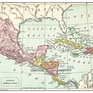
Photographic Print : Lorgues / Caribbean Map


![]()
Photo Prints from Mary Evans Picture Library
Lorgues / Caribbean Map
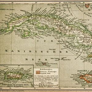
A map showing the travels of Columbus in the Caribbean
Mary Evans Picture Library makes available wonderful images created for people to enjoy over the centuries
Media ID 605451
© Mary Evans Picture Library 2015 - https://copyrighthub.org/s0/hub1/creation/maryevans/MaryEvansPictureID/10053035
1492 1502 Caribbean Columbus Lorgues Travels
10"x8" Photo Print
Discover the rich history of the Caribbean with our exquisite selection of photographic prints from Mary Evans Picture Library, featuring the captivating image "Lorgues / Caribbean Map" by Mary Evans Prints Online. This stunning print showcases an intricately detailed map depicting the voyages of Christopher Columbus and the early European exploration of the Caribbean. Bring the stories of history to life in your home or office with this beautifully crafted, high-quality print. Whether used as a standalone piece or as part of a collection, this print is sure to inspire and delight. Order yours today and let the adventures of the past come alive in the present.
Photo prints are produced on Kodak professional photo paper resulting in timeless and breath-taking prints which are also ideal for framing. The colors produced are rich and vivid, with accurate blacks and pristine whites, resulting in prints that are truly timeless and magnificent. Whether you're looking to display your prints in your home, office, or gallery, our range of photographic prints are sure to impress. Dimensions refers to the size of the paper in inches.
Our Photo Prints are in a large range of sizes and are printed on Archival Quality Paper for excellent colour reproduction and longevity. They are ideal for framing (our Framed Prints use these) at a reasonable cost. Alternatives include cheaper Poster Prints and higher quality Fine Art Paper, the choice of which is largely dependant on your budget.
Estimated Image Size (if not cropped) is 25.4cm x 18cm (10" x 7.1")
Estimated Product Size is 25.4cm x 20.3cm (10" x 8")
These are individually made so all sizes are approximate
Artwork printed orientated as per the preview above, with landscape (horizontal) orientation to match the source image.
FEATURES IN THESE COLLECTIONS
> Maps and Charts
> Early Maps
> Maps and Charts
> Related Images
EDITORS COMMENTS
This print from Mary Evans Picture Library showcases a historical map titled "Lorgues / Caribbean Map," highlighting the travels of Christopher Columbus in the Caribbean between 1492 and 1502. The intricately detailed map offers a glimpse into one of the most significant events in American history, as Columbus embarked on his groundbreaking voyages that would forever change the course of exploration and discovery.
The map not only serves as a geographical representation of Columbus's travels but also provides valuable insights into the cultural and historical significance of his expeditions. From the lush landscapes to the intricate coastlines, every detail on this map tells a story of adventure, perseverance, and discovery.
As we gaze upon this remarkable piece of history, we are transported back in time to an era filled with excitement and uncertainty. We can almost envision Columbus setting sail across uncharted waters, driven by an insatiable curiosity and a relentless desire to explore new horizons.
Whether you're a history enthusiast or simply appreciate beautiful works of art, this print is sure to captivate your imagination and inspire you to delve deeper into the fascinating world of Christopher Columbus's travels in the Caribbean. It is truly a treasure trove of historical knowledge waiting to be explored.
MADE IN THE USA
Safe Shipping with 30 Day Money Back Guarantee
FREE PERSONALISATION*
We are proud to offer a range of customisation features including Personalised Captions, Color Filters and Picture Zoom Tools
SECURE PAYMENTS
We happily accept a wide range of payment options so you can pay for the things you need in the way that is most convenient for you
* Options may vary by product and licensing agreement. Zoomed Pictures can be adjusted in the Cart.