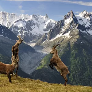
Metal Print > Maps and Charts > Americas
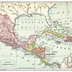
Metal Print : Lorgues / Caribbean Map


![]()
Metal Prints from Mary Evans Picture Library
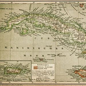
Lorgues / Caribbean Map
A map showing the travels of Columbus in the Caribbean
Mary Evans Picture Library makes available wonderful images created for people to enjoy over the centuries
Media ID 605451
© Mary Evans Picture Library 2015 - https://copyrighthub.org/s0/hub1/creation/maryevans/MaryEvansPictureID/10053035
1492 1502 Caribbean Columbus Lorgues Travels
16"x20" (51x41cm) Metal Print
Discover the rich history of the Caribbean with our stunning Metal Prints from Media Storehouse, featuring the captivating Lorgues Map of Columbus' Voyages by Mary Evans Picture Library from Mary Evans Prints Online. This intricately detailed map transports you back in time, charting the legendary explorer's journeys through the crystal-clear waters of the Caribbean Sea. With vibrant colors and sharp lines, our Metal Prints bring out the true beauty and depth of this iconic image. Elevate your home or office decor with this unique and conversation-starting piece, perfect for history enthusiasts and world travelers alike.
Made with durable metal and luxurious printing techniques, our metal photo prints go beyond traditional canvases, adding a cool, modern touch to your space. Wall mount on back. Eco-friendly 100% post-consumer recycled ChromaLuxe aluminum surface. The thickness of the print is 0.045". Featuring a Scratch-resistant surface and Rounded corners. Backing hangers are attached to the back of the print and float the print 1/2-inch off the wall when hung, the choice of hanger may vary depending on size and International orders will come with Float Mount hangers only. Finished with a brilliant white high gloss surface for unsurpassed detail and vibrance. Printed using Dye-Sublimation and for best care we recommend a non-ammonia glass cleaner, water, or isopropyl (rubbing) alcohol to prevent harming the print surface. We recommend using a clean, lint-free cloth to wipe off the print. The ultra-hard surface is scratch-resistant, waterproof and weatherproof. Avoid direct sunlight exposure.
Made with durable metal and luxurious printing techniques, metal prints bring images to life and add a modern touch to any space
Estimated Image Size (if not cropped) is 50.8cm x 40.6cm (20" x 16")
Estimated Product Size is 51.4cm x 41.2cm (20.2" x 16.2")
These are individually made so all sizes are approximate
Artwork printed orientated as per the preview above, with landscape (horizontal) orientation to match the source image.
FEATURES IN THESE COLLECTIONS
> Maps and Charts
> Early Maps
> Maps and Charts
> Related Images
EDITORS COMMENTS
This print from Mary Evans Picture Library showcases a historical map titled "Lorgues / Caribbean Map," highlighting the travels of Christopher Columbus in the Caribbean between 1492 and 1502. The intricately detailed map offers a glimpse into one of the most significant events in American history, as Columbus embarked on his groundbreaking voyages that would forever change the course of exploration and discovery.
The map not only serves as a geographical representation of Columbus's travels but also provides valuable insights into the cultural and historical significance of his expeditions. From the lush landscapes to the intricate coastlines, every detail on this map tells a story of adventure, perseverance, and discovery.
As we gaze upon this remarkable piece of history, we are transported back in time to an era filled with excitement and uncertainty. We can almost envision Columbus setting sail across uncharted waters, driven by an insatiable curiosity and a relentless desire to explore new horizons.
Whether you're a history enthusiast or simply appreciate beautiful works of art, this print is sure to captivate your imagination and inspire you to delve deeper into the fascinating world of Christopher Columbus's travels in the Caribbean. It is truly a treasure trove of historical knowledge waiting to be explored.
MADE IN THE USA
Safe Shipping with 30 Day Money Back Guarantee
FREE PERSONALISATION*
We are proud to offer a range of customisation features including Personalised Captions, Color Filters and Picture Zoom Tools
SECURE PAYMENTS
We happily accept a wide range of payment options so you can pay for the things you need in the way that is most convenient for you
* Options may vary by product and licensing agreement. Zoomed Pictures can be adjusted in the Cart.