Photographic Print > Europe > France > Canton > Landes
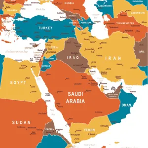
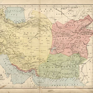
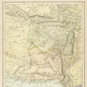
Photographic Print : 1855, Colton Map of Persia, Afghanistan, and Arabia, topography, cartography, geography


![]()
Photo Prints From Liszt Collection
1855, Colton Map of Persia, Afghanistan, and Arabia, topography, cartography, geography
1855, Colton Map of Persia, Afghanistan, and Arabia
Liszt Collection of nineteenth-century engravings and images to browse and enjoy
Media ID 14005483
© Artokoloro Quint Lox Limited
1855 Afghanistan Antique Map Latitude Longitude Mappa Mundi Old Antique Plan Old Antique View Ols Antique Map Rare Old Maps Topo
10"x8" Photo Print
Discover the rich history and geography of Persia, Afghanistan, and Arabia with our stunningly detailed 1855 Colton Map print from the Liszt Collection. This exquisite piece of cartographic artistry showcases the topography and geographical features of the region during a pivotal period in history. Bring the intrigue of the past into your home or office with this captivating and educational addition to your decor. Each print is expertly crafted using high-quality materials to ensure lasting beauty and vibrant colors, making it a true treasure for history enthusiasts, collectors, or anyone with a love for the wonders of the world.
Photo prints are produced on Kodak professional photo paper resulting in timeless and breath-taking prints which are also ideal for framing. The colors produced are rich and vivid, with accurate blacks and pristine whites, resulting in prints that are truly timeless and magnificent. Whether you're looking to display your prints in your home, office, or gallery, our range of photographic prints are sure to impress. Dimensions refers to the size of the paper in inches.
Our Photo Prints are in a large range of sizes and are printed on Archival Quality Paper for excellent colour reproduction and longevity. They are ideal for framing (our Framed Prints use these) at a reasonable cost. Alternatives include cheaper Poster Prints and higher quality Fine Art Paper, the choice of which is largely dependant on your budget.
Estimated Product Size is 25.4cm x 20.3cm (10" x 8")
These are individually made so all sizes are approximate
Artwork printed orientated as per the preview above, with landscape (horizontal) orientation to match the source image.
FEATURES IN THESE COLLECTIONS
> Asia
> Afghanistan
> Maps
> Asia
> Afghanistan
> Related Images
> Europe
> France
> Canton
> Landes
> Historic
> Space exploration
> Maps and Charts
> Early Maps
> Maps and Charts
> Related Images
> Maps and Charts
> World
EDITORS COMMENTS
This print showcases the exquisite 1855 Colton Map of Persia, Afghanistan, and Arabia. A true masterpiece in topography, cartography, and geography, this vintage map takes us on a journey through time to explore the ancient lands of the Middle East. The intricate details depicted on this historic piece of art transport us back to an era when exploration and discovery were at their peak. The carefully drawn lines represent latitude and longitude, creating a geometric grid that guides our imagination across vast regions. As we gaze upon this aged treasure, we are reminded of the importance of maps in navigation and understanding our world. Its decorative elements add a touch of elegance to its historical significance. With every contour meticulously illustrated, we can almost feel the texture of the land beneath our fingertips. This rare old map provides us with a glimpse into how these regions were perceived centuries ago. Transport yourself back in time as you admire this antique plan that once guided travelers through uncharted territories. Let your mind wander through space as you immerse yourself in this mappa mundi filled with tales from distant lands. Whether you are an avid history enthusiast or simply appreciate fine artistry, this Colton Map print is sure to captivate your senses and ignite your curiosity about these fascinating regions that have shaped our world's history for centuries.
MADE IN THE USA
Safe Shipping with 30 Day Money Back Guarantee
FREE PERSONALISATION*
We are proud to offer a range of customisation features including Personalised Captions, Color Filters and Picture Zoom Tools
SECURE PAYMENTS
We happily accept a wide range of payment options so you can pay for the things you need in the way that is most convenient for you
* Options may vary by product and licensing agreement. Zoomed Pictures can be adjusted in the Basket.