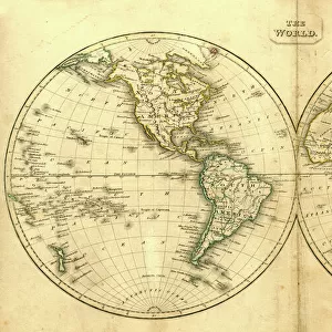
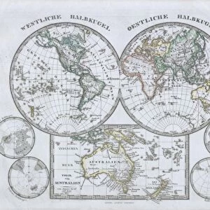
Photographic Print : 1833, School Girl Manuscript Wall Map of the World on Hemisphere Projection, Marcia


![]()
Photo Prints From Liszt Collection
1833, School Girl Manuscript Wall Map of the World on Hemisphere Projection, Marcia
1833, School Girl Manuscript Wall Map of the World on Hemisphere Projection, Marcia Rounds of Newport
Liszt Collection of nineteenth-century engravings and images to browse and enjoy
Media ID 14005045
© Artokoloro Quint Lox Limited
1833 Antique Map Latitude Longitude Mappa Mundi Old Antique Plan Old Antique View Ols Antique Map Rare Old Maps Topo
12"x8" Photo Print
Discover the captivating allure of history with our exquisite selection from the Media Storehouse range of Photographic Prints. This particular print showcases a rare and intriguing School Girl Manuscript Wall Map of the World on Hemisphere Projection, titled "Marcia," from the esteemed Liszt Collection. Dating back to 1833, this beautifully handcrafted map offers a unique glimpse into the world of yesteryears. With meticulous attention to detail, the young Marcia Rounds of Newport painstakingly illustrated continents, oceans, and various landmarks, resulting in a stunning representation of geographical knowledge during that era. Elevate your home or office décor with this captivating piece of historical art, and let the stories of the past come alive in your living space.
Photo prints are produced on Kodak professional photo paper resulting in timeless and breath-taking prints which are also ideal for framing. The colors produced are rich and vivid, with accurate blacks and pristine whites, resulting in prints that are truly timeless and magnificent. Whether you're looking to display your prints in your home, office, or gallery, our range of photographic prints are sure to impress. Dimensions refers to the size of the paper in inches.
Our Photo Prints are in a large range of sizes and are printed on Archival Quality Paper for excellent colour reproduction and longevity. They are ideal for framing (our Framed Prints use these) at a reasonable cost. Alternatives include cheaper Poster Prints and higher quality Fine Art Paper, the choice of which is largely dependant on your budget.
Estimated Product Size is 30.5cm x 20.3cm (12" x 8")
These are individually made so all sizes are approximate
Artwork printed orientated as per the preview above, with landscape (horizontal) orientation to match the source image.
EDITORS COMMENTS
This print showcases a remarkable piece of history, the "1833 School Girl Manuscript Wall Map of the World on Hemisphere Projection" created by Marcia Rounds of Newport. This meticulously hand-drawn map is an exquisite example of topography, cartography, and geography from that era. The attention to detail in this manuscript is awe-inspiring. Every landmass, illustration, and geographic feature has been carefully depicted with precision and skill. The use of latitude and longitude lines along with a grid system adds a touch of geometric elegance to the overall composition. As we gaze upon this vintage artifact, we are transported back in time to an age when maps were not just tools for navigation but also works of art. Its aged appearance evokes a sense of nostalgia while reminding us of the historical significance attached to it. This rare old map offers us a glimpse into how people perceived the world over 180 years ago. It serves as a testament to human curiosity, journeying through uncharted territories in search of discovery and exploration. Whether you are an avid collector or simply appreciate historical artifacts, this school girl manuscript wall map is sure to captivate your imagination. It represents not only our planet's geographical features but also embodies the spirit of adventure that has driven humanity throughout history.
MADE IN THE USA
Safe Shipping with 30 Day Money Back Guarantee
FREE PERSONALISATION*
We are proud to offer a range of customisation features including Personalised Captions, Color Filters and Picture Zoom Tools
SECURE PAYMENTS
We happily accept a wide range of payment options so you can pay for the things you need in the way that is most convenient for you
* Options may vary by product and licensing agreement. Zoomed Pictures can be adjusted in the Basket.