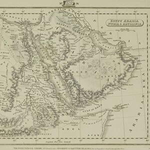
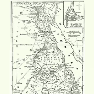
Photographic Print : 1818, Pinkerton Map of Nubia, Sudan and Abyssinia, John Pinkerton, 1758 - 1826, Scottish


![]()
Photo Prints from Liszt Collection
1818, Pinkerton Map of Nubia, Sudan and Abyssinia, John Pinkerton, 1758 - 1826, Scottish
1818, Pinkerton Map of Nubia, Sudan and Abyssinia, John Pinkerton, 1758 - 1826, Scottish antiquarian, cartographer, UK
Liszt Collection of nineteenth-century engravings and images to browse and enjoy
Media ID 14004975
© Artokoloro Quint Lox Limited
1758 1826 1758 – 1826 17581826 1818 Cartographer John Pinkerton Scottish Antiquarian Antique Map Latitude Longitude Mappa Mundi Old Antique Plan Old Antique View Ols Antique Map Rare Old Maps Topo
10"x8" Photo Print
Step back in time with our exclusive Media Storehouse antique print of the 1818 Pinkerton Map of Nubia, Sudan, and Abyssinia. This rare and intriguing map, created by renowned Scottish cartographer John Pinkerton in 1818, offers a captivating glimpse into the geography and exploration of the regions now known as Sudan and Ethiopia during the early 19th century. With intricate detail and beautiful antiquated cartography, this historic map makes a stunning addition to any room, home office, or library. Bring the rich history of cartography into your space with our authentic, museum-quality reproduction of the 1818 Pinkerton Map of Nubia, Sudan, and Abyssinia.
Photo prints are produced on Kodak professional photo paper resulting in timeless and breath-taking prints which are also ideal for framing. The colors produced are rich and vivid, with accurate blacks and pristine whites, resulting in prints that are truly timeless and magnificent. Whether you're looking to display your prints in your home, office, or gallery, our range of photographic prints are sure to impress. Dimensions refers to the size of the paper in inches.
Our Photo Prints are in a large range of sizes and are printed on Archival Quality Paper for excellent colour reproduction and longevity. They are ideal for framing (our Framed Prints use these) at a reasonable cost. Alternatives include cheaper Poster Prints and higher quality Fine Art Paper, the choice of which is largely dependant on your budget.
Estimated Image Size (if not cropped) is 25.4cm x 18.7cm (10" x 7.4")
Estimated Product Size is 25.4cm x 20.3cm (10" x 8")
These are individually made so all sizes are approximate
Artwork printed orientated as per the preview above, with landscape (horizontal) orientation to match the source image.
EDITORS COMMENTS
This print showcases the remarkable "1818, Pinkerton Map of Nubia, Sudan and Abyssinia" created by John Pinkerton, a Scottish antiquarian and cartographer. With meticulous detail and precision, Pinkerton skillfully crafted this map to depict the topography, geography, and land features of these regions in stunning clarity. The vintage allure of this ancient map is evident through its aged appearance on old paper. Its historical significance transports us back in time to an era when exploration and discovery were at their peak. This decorative piece serves as a testament to the artistry involved in early cartography. As we gaze upon this rare treasure from the past, we are reminded of the vastness of our world and how it has evolved over centuries. The intricate grid system with latitude and longitude lines adds a touch of geometric elegance to this illustration. Whether used for navigation or simply admired for its beauty, this antique map offers a glimpse into the rich history that shaped these regions. It invites us on a journey through time as we explore Nubia, Sudan, Abyssinia (now Ethiopia), and beyond. The Liszt Collection presents this print as an homage to John Pinkerton's legacy. It allows us to appreciate his contribution to geographic knowledge while also celebrating the enduring appeal of vintage maps. Let your imagination soar as you delve into the mysteries held within each contour line and landmark depicted on this extraordinary piece of cartographic art.
MADE IN THE USA
Safe Shipping with 30 Day Money Back Guarantee
FREE PERSONALISATION*
We are proud to offer a range of customisation features including Personalised Captions, Color Filters and Picture Zoom Tools
SECURE PAYMENTS
We happily accept a wide range of payment options so you can pay for the things you need in the way that is most convenient for you
* Options may vary by product and licensing agreement. Zoomed Pictures can be adjusted in the Cart.