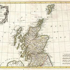
Photographic Print : 1815, Thomson Map of Southern Scotland, John Thomson, 1777 - 1840, was a Scottish


![]()
Photo Prints From Liszt Collection
1815, Thomson Map of Southern Scotland, John Thomson, 1777 - 1840, was a Scottish
1815, Thomson Map of Southern Scotland, John Thomson, 1777 - 1840, was a Scottish cartographer from Edinburgh, UK
Liszt Collection of nineteenth-century engravings and images to browse and enjoy
Media ID 14006999
© Artokoloro Quint Lox Limited
1777 1840 1815 John Thomson Antique Map Latitude Longitude Mappa Mundi Old Antique Plan Old Antique View Ols Antique Map Rare Old Maps Topo
10"x8" Photo Print
Discover the rich history of Southern Scotland with our exquisite reproduction of the 1815 Thomson Map by renowned Scottish cartographer John Thomson. This captivating piece, from the esteemed Liszt Collection, offers a unique glimpse into the cartographic detail and artistic beauty of the time. Perfect for history enthusiasts, collectors, or as a thoughtful gift, our high-quality photographic print brings the intricacies of this historic map to life, transporting you back in time. Experience the past like never before with Media Storehouse's exceptional range of Photographic Prints.
Photo prints are produced on Kodak professional photo paper resulting in timeless and breath-taking prints which are also ideal for framing. The colors produced are rich and vivid, with accurate blacks and pristine whites, resulting in prints that are truly timeless and magnificent. Whether you're looking to display your prints in your home, office, or gallery, our range of photographic prints are sure to impress. Dimensions refers to the size of the paper in inches.
Our Photo Prints are in a large range of sizes and are printed on Archival Quality Paper for excellent colour reproduction and longevity. They are ideal for framing (our Framed Prints use these) at a reasonable cost. Alternatives include cheaper Poster Prints and higher quality Fine Art Paper, the choice of which is largely dependant on your budget.
Estimated Product Size is 25.4cm x 20.3cm (10" x 8")
These are individually made so all sizes are approximate
Artwork printed orientated as per the preview above, with landscape (horizontal) orientation to match the source image.
EDITORS COMMENTS
This print showcases the exquisite 1815 Thomson Map of Southern Scotland, meticulously crafted by the talented Scottish cartographer, John Thomson. Born in Edinburgh in 1777 and passing away in 1840, Thomson left an indelible mark on the world of cartography. The map itself is a true work of art, displaying intricate details and topographical features that transport us back to a bygone era. Its carefully drawn lines depict latitude and longitude grids, offering a comprehensive understanding of the region's geography. As we gaze upon this vintage piece, we are reminded of its historical significance and its role in aiding navigation during times when technology was far from advanced. The aged appearance adds an air of authenticity to this rare old map, evoking a sense of discovery and exploration. With its decorative elements and artistic flair, this ancient relic serves as both an educational tool for geographic enthusiasts and a stunning display for history buffs. It allows us to delve into the past while appreciating the craftsmanship involved in creating such detailed representations. Whether used as an educational resource or admired purely for its aesthetic appeal, this remarkable print from Liszt Collection takes us on a journey through time – reminding us how maps have shaped our understanding of our world throughout history.
MADE IN THE USA
Safe Shipping with 30 Day Money Back Guarantee
FREE PERSONALISATION*
We are proud to offer a range of customisation features including Personalised Captions, Color Filters and Picture Zoom Tools
SECURE PAYMENTS
We happily accept a wide range of payment options so you can pay for the things you need in the way that is most convenient for you
* Options may vary by product and licensing agreement. Zoomed Pictures can be adjusted in the Basket.