Photographic Print > Animals > Mammals > Didelphidae > Formosa
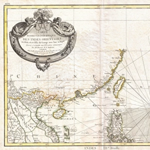
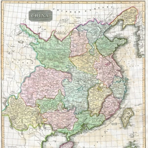
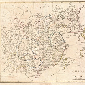
Photographic Print : 1770, Bonne Map of China, Korea, Japan and Formosa, Rigobert Bonne 1727 - 1794, one


![]()
Photo Prints from Liszt Collection
1770, Bonne Map of China, Korea, Japan and Formosa, Rigobert Bonne 1727 - 1794, one
1770, Bonne Map of China, Korea, Japan and Formosa, Rigobert Bonne 1727 - 1794, one of the most important cartographers of the late 18th century
Liszt Collection of nineteenth-century engravings and images to browse and enjoy
Media ID 14004660
© Artokoloro Quint Lox Limited
1770 Korea Rigobert Bonne 1727 1794 Rigobert Bonne 1727 – 1794 Rigobert Bonne 17271794 Antique Map Latitude Longitude Mappa Mundi Old Antique Plan Old Antique View Ols Antique Map Rare Old Maps Topo
10"x8" Photo Print
Step back in time with our exquisite Media Storehouse Photographic Print of the 1770 Rigobert Bonne Map of China, Korea, Japan, and Formosa. This rare and intriguing piece of cartographic history, hailing from the esteemed Liszt Collection, showcases the detailed work of one of the most influential cartographers of the late 18th century. With vibrant colors and crisp lines, this beautiful print is not just a map, but a window into the past, offering a glimpse into the geographical knowledge of the time. Add an air of sophistication and historical charm to your space with this stunning addition to your collection.
Photo prints are produced on Kodak professional photo paper resulting in timeless and breath-taking prints which are also ideal for framing. The colors produced are rich and vivid, with accurate blacks and pristine whites, resulting in prints that are truly timeless and magnificent. Whether you're looking to display your prints in your home, office, or gallery, our range of photographic prints are sure to impress. Dimensions refers to the size of the paper in inches.
Our Photo Prints are in a large range of sizes and are printed on Archival Quality Paper for excellent colour reproduction and longevity. They are ideal for framing (our Framed Prints use these) at a reasonable cost. Alternatives include cheaper Poster Prints and higher quality Fine Art Paper, the choice of which is largely dependant on your budget.
Estimated Image Size (if not cropped) is 25.4cm x 17.7cm (10" x 7")
Estimated Product Size is 25.4cm x 20.3cm (10" x 8")
These are individually made so all sizes are approximate
Artwork printed orientated as per the preview above, with landscape (horizontal) orientation to match the source image.
FEATURES IN THESE COLLECTIONS
> Animals
> Mammals
> Didelphidae
> Formosa
> Europe
> France
> Canton
> Landes
> Historic
> Space exploration
> Maps and Charts
> Early Maps
> Maps and Charts
> Related Images
> Maps and Charts
> World
EDITORS COMMENTS
This vintage print showcases the remarkable 1770 Bonne Map of China, Korea, Japan, and Formosa by Rigobert Bonne. As one of the most influential cartographers of the late 18th century, Bonne's expertise in topography and geography is evident in this intricate illustration. The map provides a fascinating glimpse into the world as it was known during that time period. With its detailed depiction of landforms and geographical features, this historic piece offers a valuable resource for exploration and navigation. The carefully marked grid lines indicate latitude and longitude coordinates, allowing travelers to accurately navigate through these regions centuries ago. The aged appearance adds to its charm, making it an artful decorative item that transports us back to a bygone era. This rare antique map not only serves as a testament to Bonne's skill but also represents an important chapter in our understanding of historical geography. Whether you are a history enthusiast or simply appreciate fine craftsmanship, this print from the Liszt Collection will surely ignite your curiosity about ancient civilizations and their connections across vast spaces. It serves as both an educational tool and a beautiful piece of artwork that captures the spirit of discovery prevalent during Rigobert Bonne's time.
MADE IN THE USA
Safe Shipping with 30 Day Money Back Guarantee
FREE PERSONALISATION*
We are proud to offer a range of customisation features including Personalised Captions, Color Filters and Picture Zoom Tools
SECURE PAYMENTS
We happily accept a wide range of payment options so you can pay for the things you need in the way that is most convenient for you
* Options may vary by product and licensing agreement. Zoomed Pictures can be adjusted in the Cart.