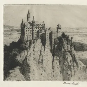
Photographic Print > Europe > France > Canton > Landes
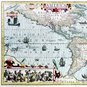
Photographic Print : 1658, Visscher Map of North America and South America, topography, cartography, geography


![]()
Photo Prints from Liszt Collection
1658, Visscher Map of North America and South America, topography, cartography, geography
1658, Visscher Map of North America and South America
Liszt Collection of nineteenth-century engravings and images to browse and enjoy
Media ID 14006560
© Artokoloro Quint Lox Limited
1658 Antique Map Latitude Longitude Mappa Mundi Old Antique Plan Old Antique View Ols Antique Map Rare Old Maps Topo
10"x8" Photo Print
Discover the captivating history of the world with our exquisite selection of vintage maps from the Media Storehouse range of Photographic Prints. This particular print showcases the 1658 Visscher Map of North America and South America, taken from the esteemed Liszt Collection. This intricately detailed map, created over 300 years ago, showcases the topography, cartography, and geography of the two continents during an era of exploration and discovery. Add this stunning piece to your home or office decor and transport yourself back in time, while adding a touch of historical charm to your space.
Photo prints are produced on Kodak professional photo paper resulting in timeless and breath-taking prints which are also ideal for framing. The colors produced are rich and vivid, with accurate blacks and pristine whites, resulting in prints that are truly timeless and magnificent. Whether you're looking to display your prints in your home, office, or gallery, our range of photographic prints are sure to impress. Dimensions refers to the size of the paper in inches.
Our Photo Prints are in a large range of sizes and are printed on Archival Quality Paper for excellent colour reproduction and longevity. They are ideal for framing (our Framed Prints use these) at a reasonable cost. Alternatives include cheaper Poster Prints and higher quality Fine Art Paper, the choice of which is largely dependant on your budget.
Estimated Product Size is 25.4cm x 20.3cm (10" x 8")
These are individually made so all sizes are approximate
Artwork printed orientated as per the preview above, with landscape (horizontal) orientation to match the source image.
FEATURES IN THESE COLLECTIONS
> Europe
> France
> Canton
> Landes
> Historic
> Space exploration
> Maps and Charts
> Early Maps
> Maps and Charts
> Related Images
> Maps and Charts
> World
> South America
> Related Images
EDITORS COMMENTS
This print showcases the remarkable 1658 Visscher Map of North America and South America, an exquisite piece of topography, cartography, and geography. With its intricate details and precise illustrations, this vintage map takes us on a journey through time, offering a glimpse into the ancient world. The carefully crafted lines and grids depict latitude and longitude with geometric precision, allowing us to navigate through these vast continents. This historical artifact holds immense value as it provides insights into the exploration and discovery that shaped our understanding of the Earth. Printed on aged paper, this decorative map exudes an air of nostalgia while reminding us of the significance of our past. Its artistic representation captures not only landforms but also cultural regions in stunning detail. From coastlines to mountain ranges, every contour is meticulously depicted. As we gaze upon this rare old map from centuries ago, we are transported back in time to an era when cartographers painstakingly mapped out uncharted territories. It serves as a reminder of how far we have come in terms of geographical knowledge while honoring those who paved the way for our modern understanding. Whether you are a history enthusiast or simply appreciate artistry from bygone eras, this antique map offers a unique window into both worlds - blending history with aesthetics seamlessly.
MADE IN THE USA
Safe Shipping with 30 Day Money Back Guarantee
FREE PERSONALISATION*
We are proud to offer a range of customisation features including Personalised Captions, Color Filters and Picture Zoom Tools
SECURE PAYMENTS
We happily accept a wide range of payment options so you can pay for the things you need in the way that is most convenient for you
* Options may vary by product and licensing agreement. Zoomed Pictures can be adjusted in the Cart.