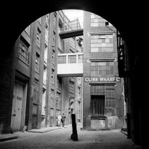
Photographic Print > Europe > United Kingdom > England > London > Towns > Lambeth
Photographic Print : Maps of England, Wales and London, 1718


![]()
Photo Prints From Heritage Images
Maps of England, Wales and London, 1718
Maps of England, Wales and London, 1718. A map of England, Wales and part of Scotland is placed between two groups of allegorical figures. Below this is a map of the City of London, City of Westminster, the River Thames, Lambeth, Southwark and surrounding areas. The lower section contains text
Heritage Images features heritage image collections
Media ID 15175430
© London Metropolitan Archives (City of London) / Heritage-Images
Cartography Lambeth Map Making Southwark Wales Allegorical Figure City Of Westminster
10"x8" Photo Print
Discover the captivating history of England, Wales, and London through the intricately detailed maps of 1718, now available as a beautiful photographic print from Media Storehouse. This vintage map, sourced from Heritage Images, showcases the countries with an exquisite border featuring allegorical figures representing Peace, Justice, and other virtues. Bring history into your home or office with this unique and thought-provoking addition to your decor.
Photo prints are produced on Kodak professional photo paper resulting in timeless and breath-taking prints which are also ideal for framing. The colors produced are rich and vivid, with accurate blacks and pristine whites, resulting in prints that are truly timeless and magnificent. Whether you're looking to display your prints in your home, office, or gallery, our range of photographic prints are sure to impress. Dimensions refers to the size of the paper in inches.
Our Photo Prints are in a large range of sizes and are printed on Archival Quality Paper for excellent colour reproduction and longevity. They are ideal for framing (our Framed Prints use these) at a reasonable cost. Alternatives include cheaper Poster Prints and higher quality Fine Art Paper, the choice of which is largely dependant on your budget.
Estimated Product Size is 25.4cm x 20.3cm (10" x 8")
These are individually made so all sizes are approximate
Artwork printed orientated as per the preview above, with landscape (horizontal) or portrait (vertical) orientation to match the source image.
FEATURES IN THESE COLLECTIONS
> Arts
> Minimalist artwork
> Monochrome artwork
> Fine art
> Arts
> Minimalist artwork
> Monochrome artwork
> Monochrome paintings
> Europe
> United Kingdom
> England
> London
> Boroughs
> City of London
> Europe
> United Kingdom
> England
> London
> Boroughs
> City of Westminster
> Europe
> United Kingdom
> England
> London
> Boroughs
> Lambeth
> Europe
> United Kingdom
> England
> London
> Boroughs
> Southwark
> Europe
> United Kingdom
> England
> London
> Museums
> British Library
> Europe
> United Kingdom
> England
> London
> River Thames
> Europe
> United Kingdom
> England
> London
> Towns
> Lambeth
> Europe
> United Kingdom
> England
> Maps
EDITORS COMMENTS
This print takes us back to the year 1718, immersing us in the rich history of England, Wales, and London. The image showcases a meticulously crafted map that depicts these regions alongside an array of allegorical figures. Placed between two groups of these symbolic representations, the map offers a glimpse into the geography and topography of England, Wales, and even part of Scotland. Beneath this grand display lies another intricate map that focuses specifically on the City of London, City of Westminster, Lambeth, Southwark, and their surrounding areas. This detailed rendering allows viewers to explore the streets and landmarks that have shaped one of the world's most iconic cities. The monochrome aesthetic adds a sense of nostalgia to this 18th-century engraving while emphasizing its historical significance. As we delve into each stroke on this print created by an anonymous artist from Britain's past centuries ago, we are transported through time. Preserved within Guildhall Library and Art Gallery today is this remarkable piece which not only serves as a testament to English cartography but also stands as a tribute to our ancestors' dedication in mapping out their country with precision. Let us cherish this extraordinary snapshot from history for its artistic beauty as well as its invaluable contribution to our understanding of geographical features during that era - all captured within one stunning image.
MADE IN THE USA
Safe Shipping with 30 Day Money Back Guarantee
FREE PERSONALISATION*
We are proud to offer a range of customisation features including Personalised Captions, Color Filters and Picture Zoom Tools
SECURE PAYMENTS
We happily accept a wide range of payment options so you can pay for the things you need in the way that is most convenient for you
* Options may vary by product and licensing agreement. Zoomed Pictures can be adjusted in the Basket.