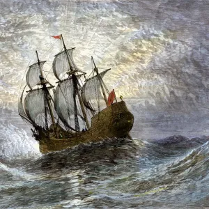
Photographic Print > Europe > United Kingdom > England > London > Art > Theatre
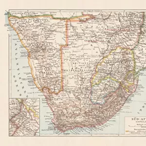
Photographic Print : Map of German South West Africa, First World War, (c1920). Creator: John Bartholomew & Son
. Creator: John Bartholomew & Son")

![]()
Photo Prints from Heritage Images
Map of German South West Africa, First World War, (c1920). Creator: John Bartholomew & Son
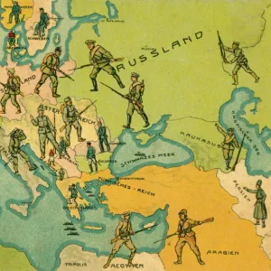
Map of German South West Africa, First World War, (c1920). The German annexation of South West Africa took place in the 1880s. After 106 years of German and South African rule, Namibia became independent in 1990. From " The Great World War - A History" Volume III, edited by Frank A Mumby. [The Gresham Publishing Company Ltd, London, c1920]
Heritage Images features heritage image collections
Media ID 19175441
© The Print Collector/Heritage Images
Bartholomew Bartholomew And Co Bartholomew Co Bartholomew John Son Frank Arthur Frank Arthur Mumby German Empire Gresham Publishing Co Ltd Gresham Publishing Company Jg Bartholomew John And Son John Bartholomew And Co John Bartholomew And Son John Bartholomew And Son Ltd John Bartholomew Co John Bartholomew Son John Bartholomew Son Ltd John Son Keystone Archives Mumby Mumby Frank Arthur Namibia Namibia Africa Occupied Territory Territorial Territory The Great World War A History Theatre Of War South West Africa
10"x8" Photo Print
Step back in time with our vintage Map of German South West Africa from the First World War era, brought to you by John Bartholomew & Son. This historical print, created around 1920, showcases the territorial claims of Germany in Africa during the early 20th century. A fascinating addition to any history or geography collection, this print offers a unique insight into the political landscape of the time. With intricate detail and accurate cartography, this is a must-have for history enthusiasts, educators, and collectors alike. Authentically reproduced from the original map held at Heritage Images, this print is a beautiful and captivating piece of history.
Photo prints are produced on Kodak professional photo paper resulting in timeless and breath-taking prints which are also ideal for framing. The colors produced are rich and vivid, with accurate blacks and pristine whites, resulting in prints that are truly timeless and magnificent. Whether you're looking to display your prints in your home, office, or gallery, our range of photographic prints are sure to impress. Dimensions refers to the size of the paper in inches.
Our Photo Prints are in a large range of sizes and are printed on Archival Quality Paper for excellent colour reproduction and longevity. They are ideal for framing (our Framed Prints use these) at a reasonable cost. Alternatives include cheaper Poster Prints and higher quality Fine Art Paper, the choice of which is largely dependant on your budget.
Estimated Product Size is 20.3cm x 25.4cm (8" x 10")
These are individually made so all sizes are approximate
Artwork printed orientated as per the preview above, with landscape (horizontal) or portrait (vertical) orientation to match the source image.
FEATURES IN THESE COLLECTIONS
> Africa
> Namibia
> Related Images
> Africa
> South Africa
> Maps
> Africa
> South Africa
> Related Images
> Europe
> United Kingdom
> England
> London
> Art
> Theatre
> Historic
> Colonial history
> Colonial art and artists
> Historic
> World War I and II
> World War I
> Historic
> World War I and II
EDITORS COMMENTS
This print showcases a historical map of German South West Africa during the First World War, dating back to approximately 1920. Created by John Bartholomew & Son, this map sheds light on the German annexation of South West Africa in the 1880s and its subsequent rule for over a century. Namibia's journey towards independence finally culminated in 1990 after enduring both German and South African governance. Extracted from "The Great World War - A History". Volume III, edited by Frank A Mumby, this image offers a glimpse into an era defined by colonialism and territorial disputes. The vibrant colors employed in this map bring life to the concept of empire-building as well as highlighting key locations along the coastal region. As we delve into this piece of history, it becomes evident that it serves not only as a geographical representation but also as a testament to the significant role played by Germany during World War I. This print is truly an invaluable resource for those seeking to understand the complexities surrounding Namibia's occupation and its place within the theatre of war. Preserved through time by Heritage Images, this remarkable artifact provides us with valuable insights into past events while reminding us of our collective responsibility to learn from history's triumphs and mistakes alike.
MADE IN THE USA
Safe Shipping with 30 Day Money Back Guarantee
FREE PERSONALISATION*
We are proud to offer a range of customisation features including Personalised Captions, Color Filters and Picture Zoom Tools
SECURE PAYMENTS
We happily accept a wide range of payment options so you can pay for the things you need in the way that is most convenient for you
* Options may vary by product and licensing agreement. Zoomed Pictures can be adjusted in the Cart.