Metal Print > Europe > United Kingdom > England > London > Art > Theatre
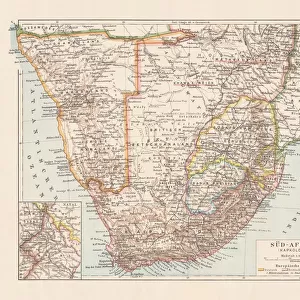
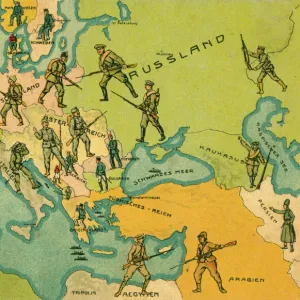
Metal Print : Map of German South West Africa, First World War, (c1920). Creator: John Bartholomew & Son
. Creator: John Bartholomew & Son")


![]()
Metal Prints from Heritage Images
Map of German South West Africa, First World War, (c1920). Creator: John Bartholomew & Son
Map of German South West Africa, First World War, (c1920). The German annexation of South West Africa took place in the 1880s. After 106 years of German and South African rule, Namibia became independent in 1990. From " The Great World War - A History" Volume III, edited by Frank A Mumby. [The Gresham Publishing Company Ltd, London, c1920]
Heritage Images features heritage image collections
Media ID 19175441
© The Print Collector/Heritage Images
Bartholomew Bartholomew And Co Bartholomew Co Bartholomew John Son Frank Arthur Frank Arthur Mumby German Empire Gresham Publishing Co Ltd Gresham Publishing Company Jg Bartholomew John And Son John Bartholomew And Co John Bartholomew And Son John Bartholomew And Son Ltd John Bartholomew Co John Bartholomew Son John Bartholomew Son Ltd John Son Keystone Archives Mumby Mumby Frank Arthur Namibia Namibia Africa Occupied Territory Territorial Territory The Great World War A History Theatre Of War South West Africa
16"x20" (51x41cm) Metal Print
Step back in time with our vintage Map of German South West Africa from the First World War era. This captivating print, created by John Bartholomew & Son in the early 1920s, showcases the territorial claims of Germany in South West Africa during that time. A fascinating historical piece, it offers a unique perspective into the geopolitical landscape of the early 20th century. Bring a piece of history into your home or office with our high-quality Metal Print, expertly crafted to bring out the intricate details of this iconic map. Each Metal Print is made using premium materials and state-of-the-art printing techniques to ensure a vibrant, long-lasting display. Order yours today and add a touch of history to your space.
Made with durable metal and luxurious printing techniques, our metal photo prints go beyond traditional canvases, adding a cool, modern touch to your space. Wall mount on back. Eco-friendly 100% post-consumer recycled ChromaLuxe aluminum surface. The thickness of the print is 0.045". Featuring a Scratch-resistant surface and Rounded corners. Backing hangers are attached to the back of the print and float the print 1/2-inch off the wall when hung, the choice of hanger may vary depending on size and International orders will come with Float Mount hangers only. Finished with a brilliant white high gloss surface for unsurpassed detail and vibrance. Printed using Dye-Sublimation and for best care we recommend a non-ammonia glass cleaner, water, or isopropyl (rubbing) alcohol to prevent harming the print surface. We recommend using a clean, lint-free cloth to wipe off the print. The ultra-hard surface is scratch-resistant, waterproof and weatherproof. Avoid direct sunlight exposure.
Made with durable metal and luxurious printing techniques, metal prints bring images to life and add a modern touch to any space
Estimated Image Size (if not cropped) is 40.6cm x 50.8cm (16" x 20")
Estimated Product Size is 41.2cm x 51.4cm (16.2" x 20.2")
These are individually made so all sizes are approximate
Artwork printed orientated as per the preview above, with portrait (vertical) orientation to match the source image.
FEATURES IN THESE COLLECTIONS
> Africa
> Namibia
> Related Images
> Africa
> South Africa
> Maps
> Africa
> South Africa
> Related Images
> Europe
> United Kingdom
> England
> London
> Art
> Theatre
> Historic
> Colonial history
> Colonial art and artists
> Historic
> World War I and II
> World War I
> Historic
> World War I and II
EDITORS COMMENTS
This print showcases a historical map of German South West Africa during the First World War, dating back to approximately 1920. Created by John Bartholomew & Son, this map sheds light on the German annexation of South West Africa in the 1880s and its subsequent rule for over a century. Namibia's journey towards independence finally culminated in 1990 after enduring both German and South African governance. Extracted from "The Great World War - A History". Volume III, edited by Frank A Mumby, this image offers a glimpse into an era defined by colonialism and territorial disputes. The vibrant colors employed in this map bring life to the concept of empire-building as well as highlighting key locations along the coastal region. As we delve into this piece of history, it becomes evident that it serves not only as a geographical representation but also as a testament to the significant role played by Germany during World War I. This print is truly an invaluable resource for those seeking to understand the complexities surrounding Namibia's occupation and its place within the theatre of war. Preserved through time by Heritage Images, this remarkable artifact provides us with valuable insights into past events while reminding us of our collective responsibility to learn from history's triumphs and mistakes alike.
MADE IN THE USA
Safe Shipping with 30 Day Money Back Guarantee
FREE PERSONALISATION*
We are proud to offer a range of customisation features including Personalised Captions, Color Filters and Picture Zoom Tools
SECURE PAYMENTS
We happily accept a wide range of payment options so you can pay for the things you need in the way that is most convenient for you
* Options may vary by product and licensing agreement. Zoomed Pictures can be adjusted in the Cart.