Photographic Print > Europe > United Kingdom > Wales > Maps
Photographic Print : England & Wales, 1859


![]()
Photo Prints from Heritage Images
England & Wales, 1859
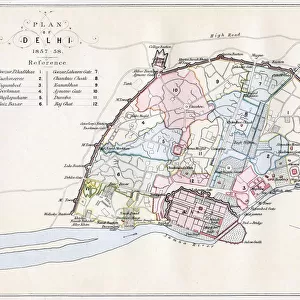
England & Wales, 1859. Jurisdiction covering England and Wales, two of the four countries of the United Kingdom. From The History of England by David Hume & Tobias Smollett. [Virtue & Co. London, 1859]
Heritage Images features heritage image collections
Media ID 14975280
© The Print Collector
Boundary Cartography Complex County David David Hume History Of England Hume Jurisdiction Map Making Smollett Tobias George Tobias George Smollett Tobias Smollett Virtue And Company Virtue Co Ltd Wales
10"x8" Photo Print
Step back in time with our exquisite Media Storehouse Photographic Print of England & Wales from 1859. This captivating image, sourced from Heritage Images, takes you on a journey to the past, showcasing the jurisdiction of England and Wales as depicted in The History of England by David Hume and Tobias Smollett, published by Virtue & Co. Add a touch of history and character to your home or office with this stunning, high-quality print. Each print is carefully crafted using premium materials to ensure lasting beauty and vibrant colors. Order yours today and let this piece of history become a cherished part of your collection.
Photo prints are produced on Kodak professional photo paper resulting in timeless and breath-taking prints which are also ideal for framing. The colors produced are rich and vivid, with accurate blacks and pristine whites, resulting in prints that are truly timeless and magnificent. Whether you're looking to display your prints in your home, office, or gallery, our range of photographic prints are sure to impress. Dimensions refers to the size of the paper in inches.
Our Photo Prints are in a large range of sizes and are printed on Archival Quality Paper for excellent colour reproduction and longevity. They are ideal for framing (our Framed Prints use these) at a reasonable cost. Alternatives include cheaper Poster Prints and higher quality Fine Art Paper, the choice of which is largely dependant on your budget.
Estimated Image Size (if not cropped) is 18.6cm x 25.4cm (7.3" x 10")
Estimated Product Size is 20.3cm x 25.4cm (8" x 10")
These are individually made so all sizes are approximate
Artwork printed orientated as per the preview above, with portrait (vertical) orientation to match the source image.
FEATURES IN THESE COLLECTIONS
> Europe
> United Kingdom
> England
> Maps
> Europe
> United Kingdom
> Wales
> Maps
> Europe
> United Kingdom
> Wales
> Posters
> Maps and Charts
> Related Images
> Maps and Charts
> Wales
EDITORS COMMENTS
This print takes us back to the year 1859, offering a glimpse into the historical jurisdiction of England and Wales. The map, featured in "The History of England" by David Hume and Tobias Smollett, showcases the intricate boundaries and counties that defined these two countries within the United Kingdom. Aesthetically pleasing with its delicate pink hues, this piece of cartography is not only a geographical representation but also a work of art. As we examine this 19th-century masterpiece, we are reminded of the complexity involved in map making during that era. Every county is meticulously outlined with precision, highlighting their unique locations within England and Wales. This print serves as an invaluable resource for historians and geographers alike who seek to understand the history and development of these regions. The collaboration between David Hume and Tobias Smollett brings together literature and cartography seamlessly. Their combined efforts have resulted in a visually stunning depiction that captures both the essence of geography and historical significance. Preserved through time by Virtue & Co. , London, this print stands as a testament to their dedication towards preserving history for future generations. It allows us to reflect upon our past while appreciating how far we have come since then. In conclusion, this print offers more than just a mere representation; it encapsulates centuries worth of knowledge about England's and Wales' jurisdictions while showcasing remarkable craftsmanship from renowned figures such as David Hume & Tobias Smollett.
MADE IN THE USA
Safe Shipping with 30 Day Money Back Guarantee
FREE PERSONALISATION*
We are proud to offer a range of customisation features including Personalised Captions, Color Filters and Picture Zoom Tools
SECURE PAYMENTS
We happily accept a wide range of payment options so you can pay for the things you need in the way that is most convenient for you
* Options may vary by product and licensing agreement. Zoomed Pictures can be adjusted in the Cart.