Photographic Print > Historic > Ancient civilizations > Roman Empire > Roman emperors
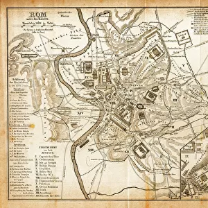
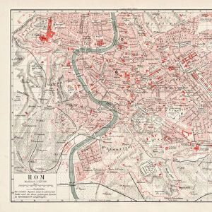
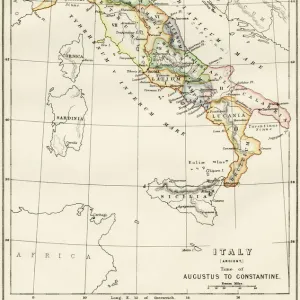
Photographic Print : ROMAN EMPIRE: MAP OF ROME. Plan of Rome at the time of Augustus, first Roman emperor, 27 B. C. -14 A. D


![]()
Photo Prints from Granger
ROMAN EMPIRE: MAP OF ROME. Plan of Rome at the time of Augustus, first Roman emperor, 27 B. C. -14 A. D
ROMAN EMPIRE: MAP OF ROME. Plan of Rome at the time of Augustus, first Roman emperor, 27 B.C.-14 A.D
Granger holds millions of images spanning more than 25,000 years of world history, from before the Stone Age to the dawn of the Space Age
Media ID 7510823
1st Century Empire Roman Roman Empire
10"x8" Photo Print
Discover the rich history of the ancient Roman Empire with our exquisite "ROMAN EMPIRE: MAP OF ROME" photographic print from Media Storehouse. This captivating image, sourced from The Granger Collection through Granger Art on Demand, showcases a meticulously detailed plan of Rome during the reign of Augustus, the first Roman emperor, from 27 BC to 14 AD. Bring the grandeur of the Roman Empire into your home or office with this stunning, museum-quality print. The intricate lines and precise details of this antique map reveal the layout of the city as it once was, offering a unique glimpse into the past. This photographic print is not only an impressive addition to any space but also serves as a thoughtful and educational gift for history enthusiasts, students, or anyone with an appreciation for the ancient world. Order your "ROMAN EMPIRE: MAP OF ROME" photographic print today and let the story of Rome unfold before your eyes.
Photo prints are produced on Kodak professional photo paper resulting in timeless and breath-taking prints which are also ideal for framing. The colors produced are rich and vivid, with accurate blacks and pristine whites, resulting in prints that are truly timeless and magnificent. Whether you're looking to display your prints in your home, office, or gallery, our range of photographic prints are sure to impress. Dimensions refers to the size of the paper in inches.
Our Photo Prints are in a large range of sizes and are printed on Archival Quality Paper for excellent colour reproduction and longevity. They are ideal for framing (our Framed Prints use these) at a reasonable cost. Alternatives include cheaper Poster Prints and higher quality Fine Art Paper, the choice of which is largely dependant on your budget.
Estimated Product Size is 25.4cm x 20.3cm (10" x 8")
These are individually made so all sizes are approximate
Artwork printed orientated as per the preview above, with landscape (horizontal) orientation to match the source image.
FEATURES IN THESE COLLECTIONS
> Arts
> Artists
> R
> Roman Roman
> Arts
> Landscape paintings
> Waterfall and river artworks
> River artworks
> Europe
> Italy
> Lazio
> Rome
> Historic
> Ancient civilizations
> Roman Empire
> Ancient Rome
> Historic
> Ancient civilizations
> Roman Empire
> Roman art
> Historic
> Ancient civilizations
> Roman Empire
> Roman emperors
> Maps and Charts
> Early Maps
> Maps and Charts
> Related Images
EDITORS COMMENTS
This print showcases a remarkable piece of history - the "ROMAN EMPIRE: MAP OF ROME". Immerse yourself in the ancient world as you explore this detailed engraving, depicting the grandeur and complexity of Rome during the reign of Augustus, the first Roman emperor. Transporting us back to 27 B. C. - 14 A. D. , this map offers a glimpse into the heart of one of history's greatest empires. Every intricate detail has been meticulously etched onto this print, allowing us to trace our fingers along the winding streets and marvel at the architectural wonders that once stood proudly in Rome. The image reveals an empire at its zenith, with sprawling buildings, bustling markets, and majestic temples lining both sides of a meandering river. The city's layout reflects meticulous planning and engineering prowess; it is evident why Rome was considered an unrivaled center for culture, politics, and power during this era. As we delve deeper into this visual treasure trove from The Granger Collection, we are reminded not only of Rome's physical splendor but also its historical significance. This map serves as a testament to how Augustus shaped his capital city into an enduring symbol of imperial might. Whether you're an avid historian or simply captivated by ancient civilizations, this print will transport you back in time to experience firsthand what life was like within the magnificent walls of ancient Rome.
MADE IN THE USA
Safe Shipping with 30 Day Money Back Guarantee
FREE PERSONALISATION*
We are proud to offer a range of customisation features including Personalised Captions, Color Filters and Picture Zoom Tools
SECURE PAYMENTS
We happily accept a wide range of payment options so you can pay for the things you need in the way that is most convenient for you
* Options may vary by product and licensing agreement. Zoomed Pictures can be adjusted in the Cart.