Photographic Print > North America > Canada > Maps
Photographic Print : Country map of Canada


![]()
Photo Prints From Fine Art Storehouse
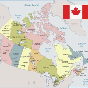
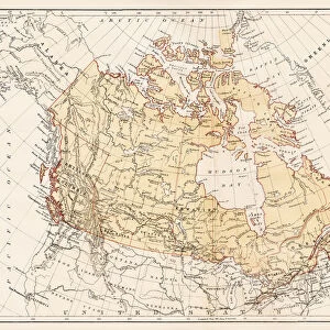
Country map of Canada
Reference Maps, 102270216
Unleash your creativity and transform your space into a visual masterpiece!
Media ID 14432301
10"x8" Photo Print
Discover the breathtaking beauty of Canada with our exquisite "Country Map of Canada" Fine Art Print from Media Storehouse. This stunning piece of art is part of our Photographic Prints collection (102270216) and is perfect for adding a touch of nature and culture to your home or office decor. Our high-quality print captures every intricate detail of the Canadian map, making it a must-have for anyone who appreciates the wonders of this vast and diverse country. Bring a piece of Canada into your space and enjoy the captivating detail and vibrant colors that will transport you right to the heart of this magnificent land.
Photo prints are produced on Kodak professional photo paper resulting in timeless and breath-taking prints which are also ideal for framing. The colors produced are rich and vivid, with accurate blacks and pristine whites, resulting in prints that are truly timeless and magnificent. Whether you're looking to display your prints in your home, office, or gallery, our range of photographic prints are sure to impress. Dimensions refers to the size of the paper in inches.
Our Photo Prints are in a large range of sizes and are printed on Archival Quality Paper for excellent colour reproduction and longevity. They are ideal for framing (our Framed Prints use these) at a reasonable cost. Alternatives include cheaper Poster Prints and higher quality Fine Art Paper, the choice of which is largely dependant on your budget.
Estimated Product Size is 25.4cm x 20.3cm (10" x 8")
These are individually made so all sizes are approximate
Artwork printed orientated as per the preview above, with landscape (horizontal) or portrait (vertical) orientation to match the source image.
FEATURES IN THESE COLLECTIONS
> Fine Art Storehouse
> Map
> Reference Maps
> Maps and Charts
> Related Images
> North America
> Canada
> Maps
> North America
> Canada
> Related Images
EDITORS COMMENTS
This print showcases a stunning country map of Canada, brought to life with vibrant colors and intricate details. The artistry of cartography is beautifully captured in this illustration, which serves as both an informative reference and a visually appealing piece of artwork. The vastness of Canada's diverse landscapes is highlighted through this vector image, depicting the country's sprawling territories from coast to coast. From the majestic Rocky Mountains in the west to the serene Atlantic coastline in the east, every province and territory is meticulously outlined, allowing viewers to explore and appreciate the immense beauty that lies within this great nation. With no people depicted on this map, it allows us to focus solely on its geographical features. This absence emphasizes how nature reigns supreme across Canada's expansive wilderness - a reminder of its untamed allure waiting to be discovered by intrepid explorers. Whether you are an avid traveler seeking inspiration for your next adventure or simply have an appreciation for fine art prints that celebrate our world's natural wonders, this depiction of Canada will surely captivate your imagination. Hang it proudly on your wall or gift it as a thoughtful present; let this remarkable piece transport you into the heartland of one of Earth's most breathtaking countries.
MADE IN THE USA
Safe Shipping with 30 Day Money Back Guarantee
FREE PERSONALISATION*
We are proud to offer a range of customisation features including Personalised Captions, Color Filters and Picture Zoom Tools
SECURE PAYMENTS
We happily accept a wide range of payment options so you can pay for the things you need in the way that is most convenient for you
* Options may vary by product and licensing agreement. Zoomed Pictures can be adjusted in the Basket.