Jigsaw Puzzle > North America > Canada > Maps
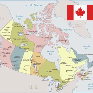
Jigsaw Puzzle : Country map of Canada


![]()
Jigsaw Puzzles From Fine Art Storehouse
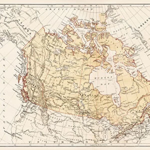
Country map of Canada
Reference Maps, 102270216
Unleash your creativity and transform your space into a visual masterpiece!
Media ID 14432301
Jigsaw Puzzle (520 Pieces)
Discover the beauty and diversity of Canada with the Media Storehouse Country Map Jigsaw Puzzle from Fine Art Storehouse (Reference Maps, 102270216). This intricately detailed puzzle features a stunning representation of the Canadian map, showcasing its vibrant provinces and territories. Perfect for puzzle enthusiasts of all ages, this challenging yet rewarding puzzle allows you to explore the wonders of Canada one piece at a time. Immerse yourself in the rich history and culture of this magnificent country as you bring the map to life. A great activity for family bonding or a personal project to enjoy at your own pace. Experience the joy of discovery with the Media Storehouse Country Map Jigsaw Puzzle.
Made in the USA, 520-piece puzzles measure 16" x 20" (40.6 x 50.8 cm). Every puzzle is meticulously printed on glossy photo paper, which has a strong 1.33 mm thickness. Delivered in a black storage cardboard box, these puzzles are both stylish and practical. (Note: puzzles contain small parts and are not suitable for children under 3 years of age.)
Jigsaw Puzzles are an ideal gift for any occasion
Estimated Product Size is 50.8cm x 40.5cm (20" x 15.9")
These are individually made so all sizes are approximate
Artwork printed orientated as per the preview above, with landscape (horizontal) or portrait (vertical) orientation to match the source image.
FEATURES IN THESE COLLECTIONS
> Maps and Charts
> Related Images
> North America
> Canada
> Maps
> North America
> Canada
> Related Images
EDITORS COMMENTS
This print showcases a stunning country map of Canada, brought to life with vibrant colors and intricate details. The artistry of cartography is beautifully captured in this illustration, which serves as both an informative reference and a visually appealing piece of artwork. The vastness of Canada's diverse landscapes is highlighted through this vector image, depicting the country's sprawling territories from coast to coast. From the majestic Rocky Mountains in the west to the serene Atlantic coastline in the east, every province and territory is meticulously outlined, allowing viewers to explore and appreciate the immense beauty that lies within this great nation. With no people depicted on this map, it allows us to focus solely on its geographical features. This absence emphasizes how nature reigns supreme across Canada's expansive wilderness - a reminder of its untamed allure waiting to be discovered by intrepid explorers. Whether you are an avid traveler seeking inspiration for your next adventure or simply have an appreciation for fine art prints that celebrate our world's natural wonders, this depiction of Canada will surely captivate your imagination. Hang it proudly on your wall or gift it as a thoughtful present; let this remarkable piece transport you into the heartland of one of Earth's most breathtaking countries.
MADE IN THE USA
Safe Shipping with 30 Day Money Back Guarantee
FREE PERSONALISATION*
We are proud to offer a range of customisation features including Personalised Captions, Color Filters and Picture Zoom Tools
SECURE PAYMENTS
We happily accept a wide range of payment options so you can pay for the things you need in the way that is most convenient for you
* Options may vary by product and licensing agreement. Zoomed Pictures can be adjusted in the Basket.