Photographic Print > Fine Art Storehouse > Map
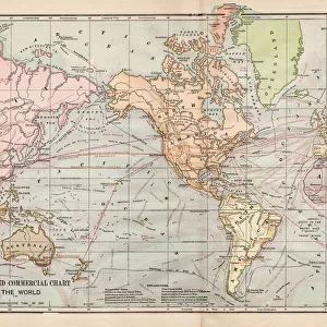
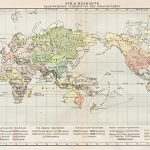
Photographic Print : Rain chart of the world 1889

![]()
Photo Prints from Fine Art Storehouse
Rain chart of the world 1889
Indiana Educational Series The Complete Geography - Indianapolis 1889
Unleash your creativity and transform your space into a visual masterpiece!
THEPALMER
Media ID 14756332
© This content is subject to copyright
Northern Goshawk Rain Southern Weathered Zones
11"x8.5" Photo Print
Step back in time with our exquisite 'Rain Chart of the World 1889' photographic print from The Palmer Collection at Media Storehouse. This rare and captivating piece is taken from the Indiana Educational Series The Complete Geography published in Indianapolis, 1889. The intricate details of the rain chart showcase the meticulous scientific knowledge of the time, making it a must-have for history buffs, cartography enthusiasts, and anyone with an appreciation for the evolution of weather mapping. Bring this piece of historical cartography into your home or office and add an air of sophistication and intrigue to your space.
Photo prints are produced on Kodak professional photo paper resulting in timeless and breath-taking prints which are also ideal for framing. The colors produced are rich and vivid, with accurate blacks and pristine whites, resulting in prints that are truly timeless and magnificent. Whether you're looking to display your prints in your home, office, or gallery, our range of photographic prints are sure to impress. Dimensions refers to the size of the paper in inches.
Our Photo Prints are in a large range of sizes and are printed on Archival Quality Paper for excellent colour reproduction and longevity. They are ideal for framing (our Framed Prints use these) at a reasonable cost. Alternatives include cheaper Poster Prints and higher quality Fine Art Paper, the choice of which is largely dependant on your budget.
Estimated Image Size (if not cropped) is 27.9cm x 17.6cm (11" x 6.9")
Estimated Product Size is 27.9cm x 21.6cm (11" x 8.5")
These are individually made so all sizes are approximate
Artwork printed orientated as per the preview above, with landscape (horizontal) orientation to match the source image.
FEATURES IN THESE COLLECTIONS
> Fine Art Storehouse
> Map
> Historical Maps
EDITORS COMMENTS
In this print titled "Rain chart of the world 1889" we are transported back to a time when geography was explored through beautifully crafted illustrations. Taken from the Indiana Educational Series, specifically "The Complete Geography - Indianapolis 1889" this print showcases an intricate rain chart that maps out precipitation patterns across the globe. The focal point of the image is undoubtedly the majestic northern goshawk perched atop the chart, symbolizing its dominance over weathered zones and climatic variations. The bird's piercing gaze seems to convey a sense of understanding and mastery over these natural phenomena. As we delve deeper into the composition, our eyes are drawn to meticulously labeled regions representing different levels of rainfall in various parts of the world. From arid deserts to lush tropical forests, each zone tells a unique story about how water shapes landscapes and ecosystems. This photograph not only serves as a visual delight but also offers valuable insights into historical scientific exploration. It reminds us of humanity's ceaseless curiosity about our planet's diverse climates and their impact on life forms inhabiting them. Captured by THEPALMER for Fine Art Storehouse, this print invites us to appreciate both artistry and knowledge intertwined within it. It encourages us to ponder upon our ever-changing environment while celebrating human endeavors in unraveling its mysteries.
MADE IN THE USA
Safe Shipping with 30 Day Money Back Guarantee
FREE PERSONALISATION*
We are proud to offer a range of customisation features including Personalised Captions, Color Filters and Picture Zoom Tools
SECURE PAYMENTS
We happily accept a wide range of payment options so you can pay for the things you need in the way that is most convenient for you
* Options may vary by product and licensing agreement. Zoomed Pictures can be adjusted in the Cart.