Photographic Print > Asia > Philippines > Maps
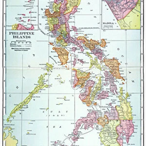
Photographic Print : Philippines map 1892


![]()
Photo Prints From Fine Art Storehouse
Philippines map 1892
Frye Grammar School Geography - 1892
Unleash your creativity and transform your space into a visual masterpiece!
THEPALMER
Media ID 14756022
© This content is subject to copyright
10"x8" Photo Print
Discover the rich history of the Philippines with our exquisite "Philippines Map 1892" print from THEPALMER's Fine Art Storehouse collection. This captivating piece, originally published in Frye Grammar School Geography in 1892, transports you back in time, offering a unique glimpse into the geography of the Philippines during a significant era. With intricate detail and stunning accuracy, this vintage map print makes a perfect addition to any home or office, adding a touch of history and character to your space. Bring the past to life with this beautiful and authentic work of art.
Photo prints are produced on Kodak professional photo paper resulting in timeless and breath-taking prints which are also ideal for framing. The colors produced are rich and vivid, with accurate blacks and pristine whites, resulting in prints that are truly timeless and magnificent. Whether you're looking to display your prints in your home, office, or gallery, our range of photographic prints are sure to impress. Dimensions refers to the size of the paper in inches.
Our Photo Prints are in a large range of sizes and are printed on Archival Quality Paper for excellent colour reproduction and longevity. They are ideal for framing (our Framed Prints use these) at a reasonable cost. Alternatives include cheaper Poster Prints and higher quality Fine Art Paper, the choice of which is largely dependant on your budget.
Estimated Product Size is 20.3cm x 25.4cm (8" x 10")
These are individually made so all sizes are approximate
Artwork printed orientated as per the preview above, with landscape (horizontal) or portrait (vertical) orientation to match the source image.
FEATURES IN THESE COLLECTIONS
> Asia
> Philippines
> Maps
> Asia
> Philippines
> Related Images
> Maps and Charts
> Related Images
EDITORS COMMENTS
This print showcases a historical gem, the Philippines map from 1892. Taken from the renowned Frye Grammar School Geography book of that era, this piece offers a fascinating glimpse into the country's past. The intricate details and vibrant colors bring to life an important chapter in Philippine history. The map itself is a testament to the meticulous craftsmanship of cartographers during that time. Every province, island, and waterway is meticulously outlined with precision and accuracy. It serves as a visual representation of how the archipelago was perceived over a century ago. As we gaze upon this vintage treasure, we are transported back to an era when exploration and discovery were at their peak. This photograph allows us to appreciate not only the geographical features but also provides insight into how knowledge was disseminated through educational materials like textbooks. "The Philippines map 1892" by THEPALMER captures our attention with its nostalgic charm and evokes curiosity about what life must have been like during that period. It reminds us of our rich cultural heritage while highlighting the importance of preserving historical artifacts for future generations. Whether you're an avid collector or simply intrigued by history, this print is sure to be a cherished addition to any space.
MADE IN THE USA
Safe Shipping with 30 Day Money Back Guarantee
FREE PERSONALISATION*
We are proud to offer a range of customisation features including Personalised Captions, Color Filters and Picture Zoom Tools
SECURE PAYMENTS
We happily accept a wide range of payment options so you can pay for the things you need in the way that is most convenient for you
* Options may vary by product and licensing agreement. Zoomed Pictures can be adjusted in the Basket.