Framed Print > Asia > Philippines > Maps
Framed Print : Philippines map 1892


![]()
Framed Photos From Fine Art Storehouse
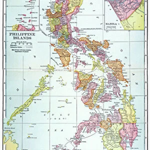
Philippines map 1892
Frye Grammar School Geography - 1892
Unleash your creativity and transform your space into a visual masterpiece!
THEPALMER
Media ID 14756022
© This content is subject to copyright
12"x10" Modern Frame
Introducing the captivating "Philippines Map 1892" Framed Print from our Media Storehouse collection at Fine Art Storehouse. This exquisite piece, crafted by THEPALMER, is a stunning representation of a historical geography map from the Frye Grammar School year of 1892. Travel back in time as you display this intricately detailed map, showcasing the Philippines archipelago as it appeared over a century ago. The vintage charm of this map adds an unique touch to any room, making it an excellent conversation starter and a beautiful addition to your decor. Bring history into your home with this exquisite framed print.
10x8 Print in an MDF Wooden Frame with 180 gsm Satin Finish Paper. Glazed using shatter proof thin plexi glass. Frame thickness is 1 inch and depth 0.75 inch. Fluted cardboard backing held with clips. Supplied ready to hang with sawtooth hanger and rubber bumpers. Spot clean with a damp cloth. Packaged foam wrapped in a card.
Contemporary Framed and Mounted Prints - Professionally Made and Ready to Hang
Estimated Image Size (if not cropped) is 25.4cm x 25.4cm (10" x 10")
Estimated Product Size is 25.4cm x 30.5cm (10" x 12")
These are individually made so all sizes are approximate
Artwork printed orientated as per the preview above, with landscape (horizontal) or portrait (vertical) orientation to match the source image.
FEATURES IN THESE COLLECTIONS
> Asia
> Philippines
> Maps
> Asia
> Philippines
> Related Images
> Maps and Charts
> Related Images
EDITORS COMMENTS
This print showcases a historical gem, the Philippines map from 1892. Taken from the renowned Frye Grammar School Geography book of that era, this piece offers a fascinating glimpse into the country's past. The intricate details and vibrant colors bring to life an important chapter in Philippine history. The map itself is a testament to the meticulous craftsmanship of cartographers during that time. Every province, island, and waterway is meticulously outlined with precision and accuracy. It serves as a visual representation of how the archipelago was perceived over a century ago. As we gaze upon this vintage treasure, we are transported back to an era when exploration and discovery were at their peak. This photograph allows us to appreciate not only the geographical features but also provides insight into how knowledge was disseminated through educational materials like textbooks. "The Philippines map 1892" by THEPALMER captures our attention with its nostalgic charm and evokes curiosity about what life must have been like during that period. It reminds us of our rich cultural heritage while highlighting the importance of preserving historical artifacts for future generations. Whether you're an avid collector or simply intrigued by history, this print is sure to be a cherished addition to any space.
MADE IN THE USA
Safe Shipping with 30 Day Money Back Guarantee
FREE PERSONALISATION*
We are proud to offer a range of customisation features including Personalised Captions, Color Filters and Picture Zoom Tools
SECURE PAYMENTS
We happily accept a wide range of payment options so you can pay for the things you need in the way that is most convenient for you
* Options may vary by product and licensing agreement. Zoomed Pictures can be adjusted in the Basket.