Photographic Print > Europe > Germany > Bielefeld
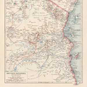
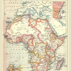
Photographic Print : German East Africa map 1896


![]()
Photo Prints From Fine Art Storehouse
German East Africa map 1896
Andres Allgemeiner Handatlas - Bielefeld und Leipzig 1896
Unleash your creativity and transform your space into a visual masterpiece!
THEPALMER
Media ID 18356855
12"x8" Photo Print
Step back in time with our exquisite reproduction of the 'German East Africa Map 1896' by THEPALMER from our Media Storehouse Fine Art collection. This intricately detailed map, originally published in Andres Allgemeiner Handatlas in Bielefeld and Leipzig, offers a captivating glimpse into the historical geography of East Africa during the late 19th century. With its rich, authentic colors and meticulous craftsmanship, this photographic print is a must-have for history enthusiasts, cartographers, and collectors alike. Bring a touch of the past into your home or office with this stunning and informative piece of historical cartography.
Photo prints are produced on Kodak professional photo paper resulting in timeless and breath-taking prints which are also ideal for framing. The colors produced are rich and vivid, with accurate blacks and pristine whites, resulting in prints that are truly timeless and magnificent. Whether you're looking to display your prints in your home, office, or gallery, our range of photographic prints are sure to impress. Dimensions refers to the size of the paper in inches.
Our Photo Prints are in a large range of sizes and are printed on Archival Quality Paper for excellent colour reproduction and longevity. They are ideal for framing (our Framed Prints use these) at a reasonable cost. Alternatives include cheaper Poster Prints and higher quality Fine Art Paper, the choice of which is largely dependant on your budget.
Estimated Product Size is 30.5cm x 20.3cm (12" x 8")
These are individually made so all sizes are approximate
Artwork printed orientated as per the preview above, with landscape (horizontal) orientation to match the source image.
FEATURES IN THESE COLLECTIONS
> Fine Art Storehouse
> Map
> Historical Maps
> Europe
> Germany
> Bielefeld
> Europe
> Germany
> Related Images
> Maps and Charts
> Related Images
EDITORS COMMENTS
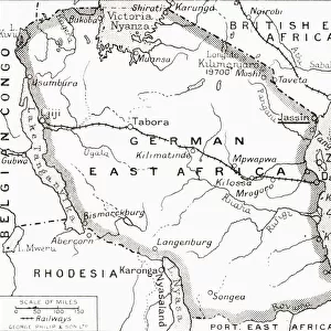
This print showcases a historical gem, the German East Africa map from 1896. A true testament to the art of cartography, this exquisite piece is sourced from Andres Allgemeiner Handatlas - Bielefeld und Leipzig 1896. With intricate details and meticulous craftsmanship, it offers a fascinating glimpse into the past. The map itself depicts the vast territory of German East Africa during its colonial era. Stretching across present-day Tanzania, Rwanda, Burundi, and parts of Mozambique and Kenya, this region was once under German rule. The borders are clearly defined with precision, showcasing towns, rivers, mountains, and other geographical features that were significant at that time. The vintage aesthetic adds an extra layer of charm to this photo print. Its sepia tones evoke nostalgia while preserving the authenticity of the original document. Whether you're a history enthusiast or simply appreciate fine art prints with cultural significance, this piece will undoubtedly captivate your imagination. "The Palmer" known for their exceptional curation in Fine Art Storehouse's collection brings forth yet another remarkable find through this photograph. As you admire this stunning reproduction on display in your home or office space, let it transport you back in time to an era when explorers ventured into uncharted territories and empires sought dominion over distant lands.
MADE IN THE USA
Safe Shipping with 30 Day Money Back Guarantee
FREE PERSONALISATION*
We are proud to offer a range of customisation features including Personalised Captions, Color Filters and Picture Zoom Tools
SECURE PAYMENTS
We happily accept a wide range of payment options so you can pay for the things you need in the way that is most convenient for you
* Options may vary by product and licensing agreement. Zoomed Pictures can be adjusted in the Basket.