Photographic Print > Fine Art Storehouse > Map
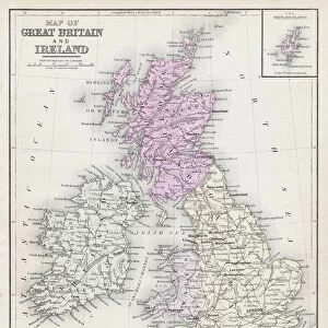
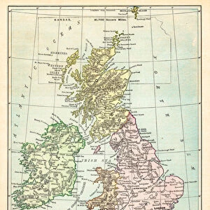
Photographic Print : British Isles map 1892


![]()
Photo Prints From Fine Art Storehouse
British Isles map 1892
Frye Grammar School Geography - 1892
Unleash your creativity and transform your space into a visual masterpiece!
THEPALMER
Media ID 14756018
© This content is subject to copyright
10"x8" Photo Print
Step back in time with our exquisite 'British Isles Map 1892' fine art print from ThePalmer at Media Storehouse. This captivating vintage map, hailing from the Frye Grammar School Geography textbook of 1892, transports you to an era of exploration and discovery. With intricate detail and rich, authentic colors, this print makes a stunning addition to any room, evoking the spirit of history and the charm of a bygone era. Bring a piece of the past into your home today with the 'British Isles Map 1892' by ThePalmer from our Fine Art Storehouse collection.
Photo prints are produced on Kodak professional photo paper resulting in timeless and breath-taking prints which are also ideal for framing. The colors produced are rich and vivid, with accurate blacks and pristine whites, resulting in prints that are truly timeless and magnificent. Whether you're looking to display your prints in your home, office, or gallery, our range of photographic prints are sure to impress. Dimensions refers to the size of the paper in inches.
Our Photo Prints are in a large range of sizes and are printed on Archival Quality Paper for excellent colour reproduction and longevity. They are ideal for framing (our Framed Prints use these) at a reasonable cost. Alternatives include cheaper Poster Prints and higher quality Fine Art Paper, the choice of which is largely dependant on your budget.
Estimated Product Size is 20.3cm x 25.4cm (8" x 10")
These are individually made so all sizes are approximate
Artwork printed orientated as per the preview above, with portrait (vertical) orientation to match the source image.
FEATURES IN THESE COLLECTIONS
> Fine Art Storehouse
> Map
> Historical Maps
EDITORS COMMENTS
This print titled "British Isles map 1892" takes us on a nostalgic journey back to the late 19th century. A relic from Frye Grammar School's geography class in 1892, this beautifully preserved piece of history showcases the intricate details and craftsmanship that went into creating educational materials during that era. The map itself is a testament to the rich cultural heritage and geographical significance of the British Isles. With its vibrant colors, delicate typography, and meticulous cartographic accuracy, it offers a glimpse into how these islands were perceived over a century ago. As we explore this vintage treasure, we are transported to an era when students would have eagerly studied every contour line and labeled city with great enthusiasm. The map not only served as an educational tool but also provided valuable insights into the political boundaries, historical landmarks, and natural features of England, Scotland, Wales, and Ireland. Expertly captured by THEPALMER for Fine Art Storehouse, this print allows us to appreciate the artistry behind such educational resources while offering a unique window into our past. Whether you're an avid collector or simply intrigued by history's visual representations, this remarkable piece will undoubtedly spark curiosity and admiration for both art enthusiasts and history buffs alike.
MADE IN THE USA
Safe Shipping with 30 Day Money Back Guarantee
FREE PERSONALISATION*
We are proud to offer a range of customisation features including Personalised Captions, Color Filters and Picture Zoom Tools
SECURE PAYMENTS
We happily accept a wide range of payment options so you can pay for the things you need in the way that is most convenient for you
* Options may vary by product and licensing agreement. Zoomed Pictures can be adjusted in the Basket.