Framed Print > Fine Art Storehouse > Map
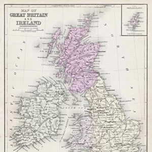
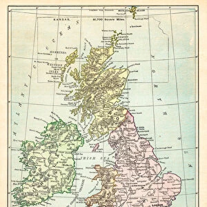
Framed Print : British Isles map 1892


![]()
Framed Photos From Fine Art Storehouse
British Isles map 1892
Frye Grammar School Geography - 1892
Unleash your creativity and transform your space into a visual masterpiece!
THEPALMER
Media ID 14756018
© This content is subject to copyright
12"x10" Modern Frame
Step back in time with our exquisite Framed Print of the "British Isles Map 1892" from THEPALMER's collection at Media Storehouse. This vintage geography piece, originally from the Frye Grammar School, showcases intricate detail and historical accuracy. Perfectly preserved in a elegant frame, this map transports you back to the late 19th century, making it an exceptional addition to your home or office. Bring a touch of antique charm to your decor while celebrating the rich history of the British Isles.
10x8 Print in an MDF Wooden Frame with 180 gsm Satin Finish Paper. Glazed using shatter proof thin plexi glass. Frame thickness is 1 inch and depth 0.75 inch. Fluted cardboard backing held with clips. Supplied ready to hang with sawtooth hanger and rubber bumpers. Spot clean with a damp cloth. Packaged foam wrapped in a card.
Contemporary Framed and Mounted Prints - Professionally Made and Ready to Hang
Estimated Image Size (if not cropped) is 25.4cm x 25.4cm (10" x 10")
Estimated Product Size is 25.4cm x 30.5cm (10" x 12")
These are individually made so all sizes are approximate
Artwork printed orientated as per the preview above, with landscape (horizontal) or portrait (vertical) orientation to match the source image.
FEATURES IN THESE COLLECTIONS
> Fine Art Storehouse
> Map
> Historical Maps
EDITORS COMMENTS
This print titled "British Isles map 1892" takes us on a nostalgic journey back to the late 19th century. A relic from Frye Grammar School's geography class in 1892, this beautifully preserved piece of history showcases the intricate details and craftsmanship that went into creating educational materials during that era. The map itself is a testament to the rich cultural heritage and geographical significance of the British Isles. With its vibrant colors, delicate typography, and meticulous cartographic accuracy, it offers a glimpse into how these islands were perceived over a century ago. As we explore this vintage treasure, we are transported to an era when students would have eagerly studied every contour line and labeled city with great enthusiasm. The map not only served as an educational tool but also provided valuable insights into the political boundaries, historical landmarks, and natural features of England, Scotland, Wales, and Ireland. Expertly captured by THEPALMER for Fine Art Storehouse, this print allows us to appreciate the artistry behind such educational resources while offering a unique window into our past. Whether you're an avid collector or simply intrigued by history's visual representations, this remarkable piece will undoubtedly spark curiosity and admiration for both art enthusiasts and history buffs alike.
MADE IN THE USA
Safe Shipping with 30 Day Money Back Guarantee
FREE PERSONALISATION*
We are proud to offer a range of customisation features including Personalised Captions, Color Filters and Picture Zoom Tools
SECURE PAYMENTS
We happily accept a wide range of payment options so you can pay for the things you need in the way that is most convenient for you
* Options may vary by product and licensing agreement. Zoomed Pictures can be adjusted in the Basket.