Photographic Print > North America > Cuba > Cuba Heritage Sites > Old Havana and its Fortification System
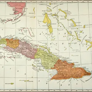
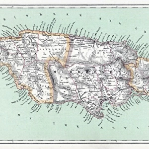
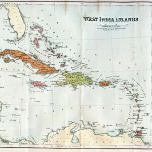
Photographic Print : Geography Atlas: description of the Caribbean Sea, Caribbean Sea (Cuba, Jamaica, Hispaniola, Jamaica), the Bahamas Islands and the Lesser Antilles with map. Plate taken from an Atlas from 1787-1810. Biblioteca Jose Marti, Havana, Cuba
, the Bahamas Islands and the Lesser Antilles with map. Plate taken from an Atlas from 1787-1810. Biblioteca Jose Marti, Havana, Cuba")

![]()
Photo Prints From Fine Art Finder
Geography Atlas: description of the Caribbean Sea, Caribbean Sea (Cuba, Jamaica, Hispaniola, Jamaica), the Bahamas Islands and the Lesser Antilles with map. Plate taken from an Atlas from 1787-1810. Biblioteca Jose Marti, Havana, Cuba
VEN5031247 Geography Atlas: description of the Caribbean Sea, Caribbean Sea (Cuba, Jamaica, Hispaniola, Jamaica), the Bahamas Islands and the Lesser Antilles with map. Plate taken from an Atlas from 1787-1810. Biblioteca Jose Marti, Havana, Cuba.; (add.info.: Geography Atlas: description of the Caribbean Sea, Caribbean Sea (Cuba, Jamaica, Hispaniola, Jamaica), the Bahamas Islands and the Lesser Antilles with map. Plate taken from an Atlas from 1787-1810. Biblioteca Jose Marti, Havana, Cuba.); © Marage Photos
Media ID 38425766
© © Marage Photos / Bridgeman Images
Amerique Centrale Amerique Du Nord Caraïbes Caribbean Caribbean Island Carte Geographique Central America Cuba Cuba Cubain Cubaine Cubains Cubaines Cuban Etats Unis Geographie Jamaica Jamaican Stockravenna 18eme Siecle Geographical Map
12"x8" Photo Print
Explore the rich history and detailed cartography of the Caribbean Sea with this stunning photographic print from Fine Art Finder. Perfect for adding a touch of vintage charm to any space, this piece captures the beauty and intricacy of an Atlas plate dating back to 1787-1810. A must-have for geography enthusiasts and art lovers alike.
Photo prints are produced on Kodak professional photo paper resulting in timeless and breath-taking prints which are also ideal for framing. The colors produced are rich and vivid, with accurate blacks and pristine whites, resulting in prints that are truly timeless and magnificent. Whether you're looking to display your prints in your home, office, or gallery, our range of photographic prints are sure to impress. Dimensions refers to the size of the paper in inches.
Our Photo Prints are in a large range of sizes and are printed on Archival Quality Paper for excellent colour reproduction and longevity. They are ideal for framing (our Framed Prints use these) at a reasonable cost. Alternatives include cheaper Poster Prints and higher quality Fine Art Paper, the choice of which is largely dependant on your budget.
Estimated Product Size is 30.5cm x 20.3cm (12" x 8")
These are individually made so all sizes are approximate
Artwork printed orientated as per the preview above, with landscape (horizontal) orientation to match the source image.
FEATURES IN THESE COLLECTIONS
> Maps and Charts
> Early Maps
> Maps and Charts
> Related Images
> North America
> The Bahamas
> Maps
> North America
> The Bahamas
> Related Images
> North America
> Cuba
> Cuba Heritage Sites
> Old Havana and its Fortification System
> North America
> Cuba
> Havana
> North America
> Cuba
> Maps
> North America
> Cuba
> Related Images
> North America
> Jamaica
> Maps
EDITORS COMMENTS
This stunning print captures a plate from an Atlas dating back to 1787-1810, showcasing the Geography Atlas description of the Caribbean Sea. The map includes details of the Caribbean Sea, Cuba, Jamaica, Hispaniola, the Bahamas Islands, and the Lesser Antilles.
The intricate engraving provides a glimpse into the geographical layout of these islands during the 18th century. The detailed representation offers a historical perspective on how these regions were depicted centuries ago.
Displayed in the Biblioteca Jose Marti in Havana, Cuba, this piece is not just a visual treat but also serves as a valuable historical artifact. It gives us insight into how cartographers viewed and mapped out these areas before modern technology revolutionized map-making.
The vibrant colors and intricate details on this map are truly mesmerizing. From the lush landscapes of Jamaica to the sprawling coastlines of Cuba and Hispaniola, every element is meticulously illustrated.
As we gaze upon this image, we are transported back in time to an era when exploration and discovery shaped our understanding of geography. This print is not just a beautiful work of art but also a window into our past that continues to fascinate and inspire us today.
MADE IN THE USA
Safe Shipping with 30 Day Money Back Guarantee
FREE PERSONALISATION*
We are proud to offer a range of customisation features including Personalised Captions, Color Filters and Picture Zoom Tools
SECURE PAYMENTS
We happily accept a wide range of payment options so you can pay for the things you need in the way that is most convenient for you
* Options may vary by product and licensing agreement. Zoomed Pictures can be adjusted in the Basket.