Photographic Print > Europe > France > Maps
Photographic Print : Map of Africa after the signing of the Anglo-French Agreement of March 1899 (colour litho)
")

![]()
Photo Prints From Fine Art Finder
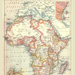
Map of Africa after the signing of the Anglo-French Agreement of March 1899 (colour litho)
2819021 Map of Africa after the signing of the Anglo-French Agreement of March 1899 (colour litho) by French School, (19th century); Private Collection; (add.info.: Map of Africa after the signing of the Anglo-French Agreement of March 1899. The agreement stipulated that French colonial expansion eastwards in Africa would stop at the watershed of the Nile. Carte de l Afrique d apres la convention Franco-Anglaise. Illustration for Le Petit Journal, 9 April 1899.); © Look and Learn
Media ID 22704932
© Look and Learn / Bridgeman Images
Agreement Boundary Colonies Diplomacy Division Foreign Relations Imperialism Scramble For Africa Britiain
10"x8" Photo Print
Step back in time with this captivating Map of Africa, showcasing the political landscape after the signing of the Anglo-French Agreement of March 1899. This beautifully detailed, colour lithograph print, hailing from the 19th century French School, offers a unique glimpse into the historical partitioning of Africa. Add an air of sophistication and intrigue to any room with this exquisite piece from the Media Storehouse range of Photographic Prints by Bridgeman Images from Fine Art Finder. A must-have for history enthusiasts and collectors alike.
Photo prints are produced on Kodak professional photo paper resulting in timeless and breath-taking prints which are also ideal for framing. The colors produced are rich and vivid, with accurate blacks and pristine whites, resulting in prints that are truly timeless and magnificent. Whether you're looking to display your prints in your home, office, or gallery, our range of photographic prints are sure to impress. Dimensions refers to the size of the paper in inches.
Our Photo Prints are in a large range of sizes and are printed on Archival Quality Paper for excellent colour reproduction and longevity. They are ideal for framing (our Framed Prints use these) at a reasonable cost. Alternatives include cheaper Poster Prints and higher quality Fine Art Paper, the choice of which is largely dependant on your budget.
Estimated Image Size (if not cropped) is 18.5cm x 25.4cm (7.3" x 10")
Estimated Product Size is 20.3cm x 25.4cm (8" x 10")
These are individually made so all sizes are approximate
Artwork printed orientated as per the preview above, with portrait (vertical) orientation to match the source image.
FEATURES IN THESE COLLECTIONS
> Fine Art Finder
> Artists
> French School
> Fine Art Finder
> Artists
> Henri (after) Meyer
> Europe
> United Kingdom
> Maps
> Maps and Charts
> British Empire Maps
> Maps and Charts
> Related Images
EDITORS COMMENTS
This vibrant and historically significant print showcases the "Map of Africa after the signing of the Anglo-French Agreement of March 1899". Created by the French School in the 19th century, this colour lithograph provides a visual representation of the diplomatic agreement between Britain and France during the era of colonial expansion. The map illustrates how this agreement dictated that French colonial expansion eastwards in Africa would cease at the watershed of the Nile. It captures a pivotal moment in history when European powers were engaged in what became known as "the scramble for Africa" vying for control over territories and resources on the continent. With its intricate details and vivid colours, this map offers valuable insights into politics, geography, and foreign relations during that time period. It highlights both British and French colonies, showcasing their spheres of influence across Africa. The division between these two European powers is evident, reflecting their respective imperial ambitions. Beyond its historical significance, this print also serves as a reminder of Europe's complex relationship with Africa. It sheds light on issues such as imperialism, colonialism, boundaries, and diplomacy that continue to shape our understanding of global politics today. Overall, this image invites viewers to explore not only African history but also broader themes related to empire building and international relations in the late 19th century.
MADE IN THE USA
Safe Shipping with 30 Day Money Back Guarantee
FREE PERSONALISATION*
We are proud to offer a range of customisation features including Personalised Captions, Color Filters and Picture Zoom Tools
SECURE PAYMENTS
We happily accept a wide range of payment options so you can pay for the things you need in the way that is most convenient for you
* Options may vary by product and licensing agreement. Zoomed Pictures can be adjusted in the Basket.