Photographic Print > Arts > Artists > C > Abraham Cresques
Photographic Print : Mapping: Map of Cathay (Catai) ancient name of Mongolian China in Central Asia and Europe
 ancient name of Mongolian China in Central Asia and Europe")

![]()
Photo Prints from Fine Art Finder
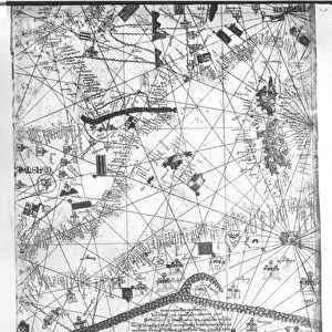
Mapping: Map of Cathay (Catai) ancient name of Mongolian China in Central Asia and Europe
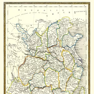
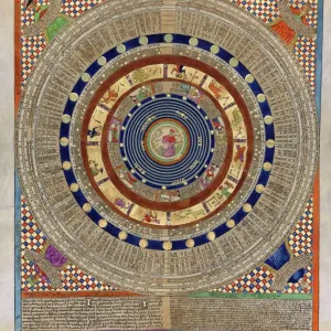
JLJ4686533 Mapping: Map of Cathay (Catai) ancient name of Mongolian China in Central Asia and Europe. There are: Delhi (India), with the Aral Sea, the Volga River, the Caspian Sea, the Caucasus, Euphrates, the Arabian Peninsula and the cities of Dehli (India) (with the Sultan), Mecca (Saudi Arabia), Baghdad (Iraq), Samarkand (Uzbekistan) and Astrakhan (Russia). Page taken from a Catalan Atlas (Catalan map) by Abraham Cresques, 1375 (Folio 5). BN, Paris by Cresques, Abraham (1325-87); Bibliotheque Nationale, Paris, France; (add.info.: Mapping: Map of Cathay (Catai) ancient name of Mongolian China in Central Asia and Europe. There are: Delhi (India), with the Aral Sea, the Volga River, the Caspian Sea, the Caucasus, Euphrates, the Arabian Peninsula and the cities of Dehli (India) (with the Sultan), Mecca (Saudi Arabia), Baghdad (Iraq), Samarkand (Uzbekistan) and Astrakhan (Russia). Page taken from a Catalan Atlas (Catalan map) by Abraham Cresques, 1375 (Folio 5). BN, Paris); Photo ePhoto Josse; Spanish, out of copyright
Media ID 22874834
© Josse / Bridgeman Images
Atlas Book Caucasus Iran Iranian Iraq Iraqi Islamic Religion Mecca Muslim Religion Saudi Arabia Asian Asian Geographical Map
10"x8" Photo Print
Discover the rich history of ancient China and Europe with our stunning photographic print of the Map of Cathay, also known as Catai. This exquisite piece, copyrighted by Photo Josse from Fine Art Finder (JLJ4686533), showcases the ancient name of Mongolian China in Central Asia and Europe. Delve into the intricacies of geography as you explore the depiction of significant landmarks such as Delhi in India, the Aral Sea, the Volga River, the Caspian Sea, and the Caucasus. Bring history to life in your home or office with this captivating and educational addition to your decor.
Photo prints are produced on Kodak professional photo paper resulting in timeless and breath-taking prints which are also ideal for framing. The colors produced are rich and vivid, with accurate blacks and pristine whites, resulting in prints that are truly timeless and magnificent. Whether you're looking to display your prints in your home, office, or gallery, our range of photographic prints are sure to impress. Dimensions refers to the size of the paper in inches.
Our Photo Prints are in a large range of sizes and are printed on Archival Quality Paper for excellent colour reproduction and longevity. They are ideal for framing (our Framed Prints use these) at a reasonable cost. Alternatives include cheaper Poster Prints and higher quality Fine Art Paper, the choice of which is largely dependant on your budget.
Estimated Product Size is 20.3cm x 25.4cm (8" x 10")
These are individually made so all sizes are approximate
Artwork printed orientated as per the preview above, with landscape (horizontal) or portrait (vertical) orientation to match the source image.
FEATURES IN THESE COLLECTIONS
> Fine Art Finder
> Artists
> Abraham Cresques
> Fine Art Finder
> Artists
> Ferdinand Victor Eugene Delacroix
> Arts
> Artists
> C
> Abraham Cresques
> Asia
> India
> Related Images
> Asia
> Iran
> Lakes
> Caspian Sea
> Asia
> Iran
> Related Images
EDITORS COMMENTS
This print showcases a historic map titled "Mapping: Map of Cathay (Catai) ancient name of Mongolian China in Central Asia and Europe". Created by Abraham Cresques in 1375, this Catalan Atlas provides a fascinating glimpse into the geographical knowledge and cartographic skills of the time. The map depicts various regions and landmarks, including Delhi in India, with its Sultan ruling over the city. It also highlights significant bodies of water such as the Aral Sea, Volga River, and Caspian Sea. The Caucasus Mountains stand prominently on the map alongside major cities like Mecca in Saudi Arabia, Baghdad in Iraq, Samarkand in Uzbekistan, and Astrakhan in Russia. One cannot help but marvel at how this intricate piece captures not only the physical landscape but also cultural connections between different civilizations during that era. The inclusion of these diverse locations reflects an understanding of trade routes and political boundaries across Central Asia and Europe. Preserved within the Bibliotheque Nationale in Paris today, this page from Cresques' Catalan Atlas serves as a testament to his mastery as a cartographer. Its historical significance lies not only in its accuracy for its time but also as evidence of early exploration efforts that shaped our understanding of geography. Through this print from Fine Art Finder's collection by Photo Josse, viewers can appreciate both the artistry behind medieval maps and their invaluable role in documenting our shared human history.
MADE IN THE USA
Safe Shipping with 30 Day Money Back Guarantee
FREE PERSONALISATION*
We are proud to offer a range of customisation features including Personalised Captions, Color Filters and Picture Zoom Tools
SECURE PAYMENTS
We happily accept a wide range of payment options so you can pay for the things you need in the way that is most convenient for you
* Options may vary by product and licensing agreement. Zoomed Pictures can be adjusted in the Cart.