Photo Mug > Europe > United Kingdom > England > Sussex > Aldingbourne
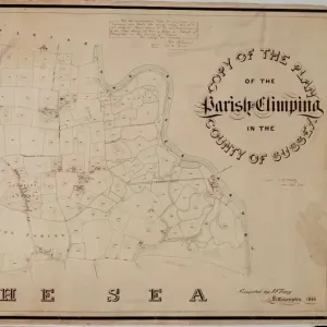
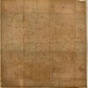
Photo Mug : Aldingbourne Tithe Map, 1846


![]()
Home Decor From West Sussex County Council
Aldingbourne Tithe Map, 1846
By E. Fuller, Chichester. 13.3 in. to 1 m. Original map size 62in. × 41in.
Tithe Award Map Collection
West Sussex Record Office Ref No: TD/W1
West Sussex County Council Record Office contains a fascinating history of the county of West Sussex, England
Media ID 7914385
© West Sussex County Council - All Rights Reserved
Large Photo Mug (15 oz)
Bring history to your morning ritual with our Media Storehouse Photo Mug featuring an intriguing image from the past. This mug showcases a captivating 1846 Aldingbourne Tithe Map from West Sussex County Council. Meticulously reproduced from the original map held at the West Sussex Record Office, this mug showcases the intricate details of the map, including field boundaries and property outlines. Each sip from this mug transports you back in time, making it a unique and thoughtful gift for history enthusiasts or a delightful addition to your own collection. Order yours today and start your day with a dose of history!
Elevate your coffee or tea experience with our premium white ceramic mug. Its wide, comfortable handle makes drinking easy, and you can rely on it to be both microwave and dishwasher safe. Sold in single units, preview may show both sides of the same mug so you can see how the picture wraps around.
Elevate your coffee or tea experience with our premium white ceramic mug. Its wide, comfortable handle makes drinking easy, and you can rely on it to be both microwave and dishwasher safe. Sold in single units, preview may show both sides of the same mug so you can see how the picture wraps around.
These are individually made so all sizes are approximate
FEATURES IN THESE COLLECTIONS
> Europe
> United Kingdom
> England
> Sussex
> Aldingbourne
> Europe
> United Kingdom
> England
> Sussex
> Chichester
> Europe
> United Kingdom
> England
> Sussex
> Related Images
> Europe
> United Kingdom
> England
> West Sussex
> Chichester
> Europe
> United Kingdom
> England
> West Sussex
> Related Images
> Maps and Charts
> Early Maps
> Maps and Charts
> Related Images
> West Sussex County Council
> West Sussex Record Office
> Tithe Award Maps, 1808-1859
EDITORS COMMENTS
This print showcases the Aldingbourne Tithe Map of 1846, a remarkable piece of historical mapping created by E. Fuller from Chichester. The map's scale is an impressive 13.3 inches to 1 meter, with its original size measuring an astonishing 62 inches by 41 inches. Preserved within the esteemed Tithe Award Map Collection at the West Sussex Record Office, this artifact offers a fascinating glimpse into the past. The Aldingbourne Tithe Map holds great significance as it provides valuable insights into land ownership and usage during the mid-19th century in West Sussex County Council. With meticulous detail and precision, it documents various plots of land, highlighting boundaries and indicating their purpose or owner. As we delve into history through this image, we are transported back to a time when agriculture played a vital role in shaping communities. This map serves as a testament to the importance of tithes - taxes paid on agricultural produce - which were collected for religious institutions. While admiring this photo print, one cannot help but appreciate its historical value and marvel at how far cartography has come since then. It stands not only as an invaluable resource for researchers and historians but also as a reminder of our rich heritage
MADE IN THE USA
Safe Shipping with 30 Day Money Back Guarantee
FREE PERSONALISATION*
We are proud to offer a range of customisation features including Personalised Captions, Color Filters and Picture Zoom Tools
SECURE PAYMENTS
We happily accept a wide range of payment options so you can pay for the things you need in the way that is most convenient for you
* Options may vary by product and licensing agreement. Zoomed Pictures can be adjusted in the Basket.