Canvas Print > Europe > United Kingdom > England > Sussex > Aldingbourne
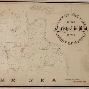
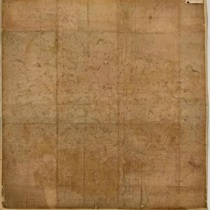
Canvas Print : Aldingbourne Tithe Map, 1846


![]()
Canvas Prints From West Sussex County Council
Aldingbourne Tithe Map, 1846
By E. Fuller, Chichester. 13.3 in. to 1 m. Original map size 62in. × 41in.
Tithe Award Map Collection
West Sussex Record Office Ref No: TD/W1
West Sussex County Council Record Office contains a fascinating history of the county of West Sussex, England
Media ID 7914385
© West Sussex County Council - All Rights Reserved
30"x20" (76x51cm) Canvas Print
Step back in time with our exquisite Canvas Print of the Aldingbourne Tithe Map from 1846. This intriguing piece of history, originally from the West Sussex Record Office, offers a captivating glimpse into the past. Meticulously reproduced on high-quality canvas, the stunning detail of E. Fuller's original map of Aldingbourne, Chichester, comes alive. Bring this piece of West Sussex heritage into your home and add a unique touch to your decor while preserving a piece of local history. Order now and explore the story that lies within the lines of this beautifully preserved Tithe Map.
Delivered stretched and ready to hang our premium quality canvas prints are made from a polyester/cotton blend canvas and stretched over a 1.25" (32mm) kiln dried knot free wood stretcher bar. Packaged in a plastic bag and secured to a cardboard insert for safe transit.
Canvas Prints add colour, depth and texture to any space. Professionally Stretched Canvas over a hidden Wooden Box Frame and Ready to Hang
Estimated Product Size is 50.8cm x 76.2cm (20" x 30")
These are individually made so all sizes are approximate
Artwork printed orientated as per the preview above, with portrait (vertical) orientation to match the source image.
FEATURES IN THESE COLLECTIONS
> Europe
> United Kingdom
> England
> Sussex
> Aldingbourne
> Europe
> United Kingdom
> England
> Sussex
> Chichester
> Europe
> United Kingdom
> England
> Sussex
> Related Images
> Europe
> United Kingdom
> England
> West Sussex
> Chichester
> Europe
> United Kingdom
> England
> West Sussex
> Related Images
> Maps and Charts
> Early Maps
> Maps and Charts
> Related Images
EDITORS COMMENTS
This print showcases the Aldingbourne Tithe Map of 1846, a remarkable piece of historical mapping created by E. Fuller from Chichester. The map's scale is an impressive 13.3 inches to 1 meter, with its original size measuring an astonishing 62 inches by 41 inches. Preserved within the esteemed Tithe Award Map Collection at the West Sussex Record Office, this artifact offers a fascinating glimpse into the past. The Aldingbourne Tithe Map holds great significance as it provides valuable insights into land ownership and usage during the mid-19th century in West Sussex County Council. With meticulous detail and precision, it documents various plots of land, highlighting boundaries and indicating their purpose or owner. As we delve into history through this image, we are transported back to a time when agriculture played a vital role in shaping communities. This map serves as a testament to the importance of tithes - taxes paid on agricultural produce - which were collected for religious institutions. While admiring this photo print, one cannot help but appreciate its historical value and marvel at how far cartography has come since then. It stands not only as an invaluable resource for researchers and historians but also as a reminder of our rich heritage
MADE IN THE USA
Safe Shipping with 30 Day Money Back Guarantee
FREE PERSONALISATION*
We are proud to offer a range of customisation features including Personalised Captions, Color Filters and Picture Zoom Tools
SECURE PAYMENTS
We happily accept a wide range of payment options so you can pay for the things you need in the way that is most convenient for you
* Options may vary by product and licensing agreement. Zoomed Pictures can be adjusted in the Basket.