Photo Mug > Europe > United Kingdom > England > Maps
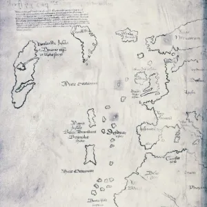
Photo Mug : Scandinavia and the North Atlantic, 1570


![]()
Home Decor from Universal Images Group (UIG)
Scandinavia and the North Atlantic, 1570
Map of Northern Europe 1570, Ortelius
Universal Images Group (UIG) manages distribution for many leading specialist agencies worldwide
Media ID 20165341
1570 Antiquarian Antiquarian Maps Early Greenland Journeys Maps Musical Northern Oceans Scandinavia Ships Travels Treks Trip Trips Voyage Voyages Monsters Roam
Large Photo Mug (15 oz)
Bring the beauty of historic cartography into your daily routine with our Media Storehouse Photo Mug featuring a captivating map of Scandinavia and the North Atlantic from PicturesNow UIG by Universal Images Group (Ortelius, 1570). This high-quality mug showcases intricate details of the map, transporting you back in time with every sip. Perfect for tea or coffee, this mug is not only a functional addition to your kitchen but also a unique conversation starter. Embrace the rich history of cartography and make your mug collection truly exceptional.
Elevate your coffee or tea experience with our premium white ceramic mug. Its wide, comfortable handle makes drinking easy, and you can rely on it to be both microwave and dishwasher safe. Sold in single units, preview may show both sides of the same mug so you can see how the picture wraps around.
Elevate your coffee or tea experience with our premium white ceramic mug. Its wide, comfortable handle makes drinking easy, and you can rely on it to be both microwave and dishwasher safe. Sold in single units, preview may show both sides of the same mug so you can see how the picture wraps around.
These are individually made so all sizes are approximate
FEATURES IN THESE COLLECTIONS
> Arts
> Artists
> O
> Oceanic Oceanic
> Europe
> United Kingdom
> England
> Maps
> Maps and Charts
> Early Maps
> Maps and Charts
> Related Images
> North America
> Greenland
> Maps
> North America
> Greenland
> Related Images
> Universal Images Group (UIG)
> History
> Historical Maps
EDITORS COMMENTS
This print takes us back in time to the year 1570, showcasing an exquisite map of Scandinavia and the North Atlantic. Created by Ortelius, a renowned cartographer of his era, this antique piece offers a glimpse into the early exploration and navigation of Northern Europe. The map is filled with intricate details that transport us to a world where sea voyages were both treacherous and awe-inspiring. Ships gracefully roam the vast oceans, symbolizing the adventurous spirit of those who dared to embark on these perilous journeys. As we trace our eyes across the map, we encounter mythical monsters lurking in uncharted territories, reminding us of the fearsome legends that accompanied seafarers during their travels. Scandinavia stands proudly at the center of this masterpiece, its lush green landscapes inviting curiosity and wanderlust. The musical notes scattered throughout hint at a vibrant cultural scene flourishing within these lands centuries ago. This print serves as a visual time capsule, allowing us to immerse ourselves in an era when maps were not just navigational tools but also works of art. It invites us to reflect on our own voyages through life – both literal and metaphorical – as we marvel at how far humanity has come since those early days of exploration.
MADE IN THE USA
Safe Shipping with 30 Day Money Back Guarantee
FREE PERSONALISATION*
We are proud to offer a range of customisation features including Personalised Captions, Color Filters and Picture Zoom Tools
SECURE PAYMENTS
We happily accept a wide range of payment options so you can pay for the things you need in the way that is most convenient for you
* Options may vary by product and licensing agreement. Zoomed Pictures can be adjusted in the Cart.