Photo Mug > Maps and Charts > Americas
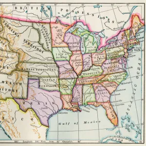
Photo Mug : United States in 1860


![]()
Home Decor from North Wind
United States in 1860
United States and territories at the beginning of the Civil War.
Printed lithograph map
North Wind Picture Archives brings history to life with stock images and hand-colored illustrations
Media ID 5880421
© North Wind Picture Archives
1860 America Civil War State Territory
Large Photo Mug (15 oz)
Introducing the Media Storehouse Photo Mug, a perfect blend of history and functionality. Featuring an iconic image from North Wind Picture Archives, this mug showcases an intriguing snapshot of the United States in 1860 - a lithograph map depicting the United States and its territories at the onset of the Civil War. Ideal for history enthusiasts or as a unique gift, each mug holds your favorite beverage while providing a captivating visual journey back in time. Crafted with premium quality materials and vibrant, long-lasting prints, this Photo Mug is not only a functional addition to your daily routine but also a conversation starter. Embrace the past, savor the present, and enjoy your favorite drink in style with the Media Storehouse Photo Mug.
Elevate your coffee or tea experience with our premium white ceramic mug. Its wide, comfortable handle makes drinking easy, and you can rely on it to be both microwave and dishwasher safe. Sold in single units, preview may show both sides of the same mug so you can see how the picture wraps around.
Elevate your coffee or tea experience with our premium white ceramic mug. Its wide, comfortable handle makes drinking easy, and you can rely on it to be both microwave and dishwasher safe. Sold in single units, preview may show both sides of the same mug so you can see how the picture wraps around.
These are individually made so all sizes are approximate
FEATURES IN THESE COLLECTIONS
> North Wind Picture Archives
> Exploration
> North Wind Picture Archives
> Maps
> Maps and Charts
> Related Images
> North America
> Related Images
EDITORS COMMENTS
This lithograph map takes us back to the year 1860, a pivotal time in American history. As we gaze upon this vintage print, we are transported to an era of great significance - the beginning of the Civil War. The United States and its territories are vividly depicted, showcasing the vastness and diversity of this young nation. Every state is meticulously illustrated, capturing their unique characteristics and boundaries. From the bustling cities on the East Coast to the untamed wilderness of the West, this map serves as a visual testament to America's growth during this period. The artistry displayed in this print is truly remarkable. Each stroke brings life to every detail - from intricate coastlines and rivers that crisscross through landscapes, to mountains majestically rising above plains. It is evident that great care was taken in creating such a historically accurate representation. As we examine this piece further, it becomes apparent how deeply intertwined these lands were with impending conflict. The divisions between states foreshadowed tensions that would soon erupt into one of America's bloodiest wars - the Civil War. This lithograph map not only preserves our heritage but also reminds us of our past struggles and triumphs as a nation united under one flag. It stands as both an educational tool for understanding history and a work of art that captures an important chapter in America's story.
MADE IN THE USA
Safe Shipping with 30 Day Money Back Guarantee
FREE PERSONALISATION*
We are proud to offer a range of customisation features including Personalised Captions, Color Filters and Picture Zoom Tools
SECURE PAYMENTS
We happily accept a wide range of payment options so you can pay for the things you need in the way that is most convenient for you
* Options may vary by product and licensing agreement. Zoomed Pictures can be adjusted in the Cart.